

Location: Aza-Tochi, Shirakawa-mura, Ono-gun, Gifu-ken
View of the levee from the bridge on the opposite bank
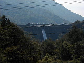
I have no idea which is the official name of the Omaki Dam, or why it is called by two different names, since it is written as the Hatoya Dam on some maps, but I would like to write them both together here.
It is located 12-13 km north of the Mimogi Dam on Route 156 in a straight line. Shirakawa-go, famous for its World Heritage Site of gassho-zukuri palms, is located nearby, and the nearby roads are crowded with sightseeing buses.
dam characteristics
| da mu | form (something takes) | gravity-fed concrete dam |
|---|---|---|
| Bank height | 63.2m | |
| Bank length | 331.5m | |
| Dam volume | 206,000m3 | |
| savings water (esp. cool, fresh water, e.g. drinking water) pond | Watershed Area | 580 km2 |
| Reservoir area | 151ha | |
| Total storage capacity | 33,539,000m3 | |
| Effective water storage capacity | 4,387,000m3 | |
| Year Completed | 1956 | |
Other facilities/observations
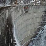
| Parking lot | × | First of all, I apologize m(__)m I only have one photo this time.... It was difficult to find a good shooting point, and this was the only shot I could get. I wanted to get a closer shot because they were discharging.... But they say they release the fish every day. |
|---|---|---|
| Toilet | × | |
| Park | × | |
| PR Exhibition Hall | × |

Comment