
Location: Sakagawa, Kamado-cho, Mizunami City, Gifu Prefecture
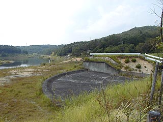
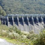
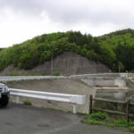
View of the embankment (?) View of the dam lake from

From National Route 19, head north on Gifu Prefectural Route 65 and turn left on the way. Not only is the location difficult to find, but the embankment is also difficult to find. When you notice it, you will see that it is a dike....
dam characteristics
| da mu | form (something takes) | Central core typeearth dam |
|---|---|---|
| Objective | Flood control and agricultural disaster prevention | |
| Bank height | 19.7m | |
| Bank length | 100.0m | |
| Dam volume | 41,000m3 | |
| savings water (esp. cool, fresh water, e.g. drinking water) pond | Total storage capacity | 698,000m3 |
| Effective water storage capacity | 698,000m3 | |
| Name of Dam Lake | Yongin Lake | |
| River Name | Shonai River System Reverse River | |
| Year of launch | 1960. | |
| Year Completed | 1963. | |
Other facilities/observations
| Parking lot | ○ | It is like a large park and there are many things to see and do around the area. There is a waterfall, a cart driving range a short distance away, and the sound of explosions echoing all the way around the dam. I actually went to see the cart driving range, and when I found out it was a cart driving range, I thought, "What the heck...," but it was quite interesting just to watch. I highly recommend going to see it in combination with a visit to the dam. |
|---|---|---|
| Toilet | ○ | |
| Park | ○ | |
| PR Exhibition Hall | × |
Comment