
A huge dam that is completely closed.
Location: Neo Kamioosu, Honzu City, Gifu Prefecture, Japan
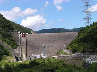
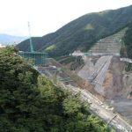
View of the levee from the downstream side of the left bank

To reach Kamiosu Dam, get off at the Seki IC of the Tokai-Hokuriku Expressway, drive east on Route 248, and turn left at that intersection after getting off the elevated road. Go north on Prefectural Road No. 17, turn left at the Ohdoro intersection, and continue west on National Road No. 418 toward Kyu-Neo Village, famous for its Usuzumi cherry blossoms. Once in the former Nebo Village, turn right on the first Prefectural Road 255. Follow the road the rest of the way.
However, this time, at the entrance to the prefectural road, there was a sign that said "no traffic ahead".... Well, as usual, we decided to go as far as we could go. However, it seemed that the roads around the levee had been severely damaged by Typhoon No. 6 in July 2002, and the roads around the levee were completely closed to traffic. So, this time, I only took pictures from the downstream side.
View of the emergency flood discharge from the downstream side of the left bank
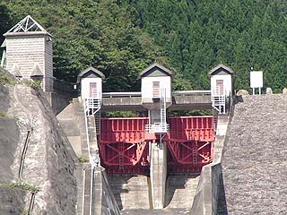
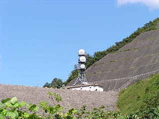
I made full use of the telephoto function of my digital camera. The emergency flood discharge has two radial gates. The triangular-roofed gate operation room looks cute.
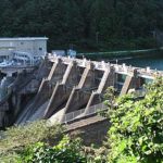
View of the power generation facility from the downstream side of the left bank
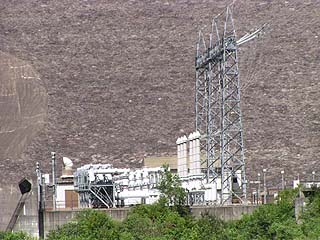
Kamiosu Dam also functions as the lower reservoir for a pure lift power plant (Okumino Hydroelectric Power Plant). This is believed to be a power generation facility for this purpose.
And the upper reservoir? As mentioned above, it was closed to traffic and we had to pass through a road controlled by Chubu Electric Power Company, so we were not able to cover it. According to the information, you have to apply to Chubu Electric Power Company for a visit to the Kawaura Dam in advance, but it seems that it is completely off-limits to all but related parties, so it is not possible to apply now. Chubu Electric Power Company has a closed image, but it seems that repair work due to typhoons is a fact, and there were some prefabricated buildings that looked like a kitchen.
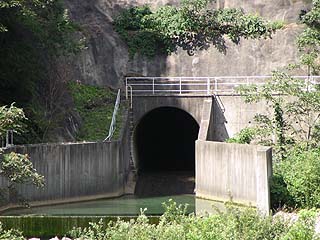
View of the outlet from the downstream side of the left bank
View of the administration building from the downstream side of the left bank
We have no idea what the top end looks like. We can't even see the dam lake. Oh, I want to see where it goes...
dam characteristics
| da mu | form (something takes) | rockfill dam |
|---|---|---|
| Objective | generation (e.g. power) | |
| Bank height | 98m | |
| Bank length | 294.5m | |
| Dam volume | 3,150,000m3 | |
| savings water (esp. cool, fresh water, e.g. drinking water) pond | Watershed Area | 12km2 |
| Reservoir area | 45 ha | |
| Total storage capacity | 14,500,000m3 | |
| Effective water storage capacity | 9,000,000m3 | |
| River Name | Kiso River System Neohigashigaya River | |
| Year of launch | 1976 | |
| Year Completed | 1995 | |
Other facilities/observations
| Parking lot | × | It is a great pity that we could not cover this dam at all, even though it is such a large scale dam. I hope the restoration work will be completed soon. |
|---|---|---|
| Toilet | × | |
| Park | × | |
| PR Exhibition Hall | × |
Comment