
Location: Shimomizo, Sagamihara City, Kanagawa Prefecture
Date of interview: July 17, 2004
View of the top edge from the right bank

This is the first appearance of a dam in the Kanto area on this site.
The Sagamihara Sedimentation Pond is identified on the map as the "Yokohama Waterworks Sedimentation Pond. As the name suggests, it is located on the Yokohama Waterway, which carries water from the Sagami River to Yokohama, and is a facility for sedimentation treatment of impurities in the water. In order to transport the water to Yokohama, iron pipes are buried underground, and the area has been greened to create the "Yokohama Suido Michi Ryokudo" (Yokohama Waterway Greenway), which is a walking path for local residents. There are many waterworks facilities around this area, making it a good place to learn about waterworks.
View of the embankment (lake side) from the right bank
 from the right bank")
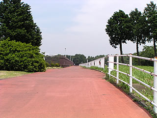
The top end is closed to motor vehicle traffic, but is maintained as a footpath for Prefectural Route 52, which passes nearby. The map also shows the sky end as a prefectural road. In other words, it's a prefectural road at the top of the skyline for pedestrians and bicycles only.
Still, it is difficult to tell which bank is upstream or downstream, left bank or right bank, at a glance from just a photograph. In the first place, it is doubtful whether such a concept even exists.
View of the right bank from the top

The entire dam lake is fenced off, but because the dam is located within the prefectural Sagamihara Park, it has been designated as one of the "50 best bird-watching spots in Kanagawa" and is an excellent spot for bird watching.
Upstream from the top View upstream (?) from the top
 from the top")
After water used for power generation at Sagami Lake is discharged, water is taken at the Numamoto Dam, pumped to the Tsukui and Shimokusawa Diversion Ponds, and then transported by underground pipes to the Sagamihara Sedimentation Pond. It is, so to speak, a little bit like going to a water rest stop, getting ready, putting on some extra clothes, and going back to the big city of Yokohama in a clean and fresh appearance.
View of the top edge (downstream) from the right bank
 from the right bank")
On the left is Sagamihara Prefectural Park, and the bridge slightly right of center is Prefectural Route 52. At a quick glance, it looks like a bank.
dam characteristics
| da mu | Model | earth dam |
|---|---|---|
| Objective | water for drinking water | |
| Bank height | 18.5m | |
| Bank length | 255m | |
| savings water (esp. cool, fresh water, e.g. drinking water) pond | Reservoir area | 12 ha |
| Total storage capacity | 883,000m3 | |
| Effective water storage capacity | 700,000m3 | |
| Name of Dam Lake | Yokohama Sewage Sedimentation Pond | |
| River Name | Sagami River System Yokohama Waterworks | |
| Year of launch | – | |
| Year Completed | 1952 | |
| Access to D@M | Get off at Yokohama Machida IC of Tomei Expressway→Take Route 16 northward toward Sagamihara→Take Route 16 northward toward Sagamihara→Take Route 16 northward toward Sagamihara After entering Sagamihara City, turn left at the "Wakamatsu 2-chome" intersection onto Prefectural Road No. 52. Follow the road westward to the intersection called "Park Entrance", A little further on, you can catch a glimpse of an embankment on your right. If you want to take a closer look, there is a T signal intersection called "Sagamihara Koen-mae", Turn left and park your car in the parking lot of Sagamihara Park (fee required). | |
Other facilities/observations
| Parking lot | ○ | Anyway, national highway 16 and other roads were heavily congested, and I realized that it could not be compared to Nagoya. Traffic jams are not a big deal in Nagoya, but in Kanagawa, there are traffic jams everywhere, The schedule we had made was a mess, and by the time we arrived at the Sagamihara Reservoir Dam, it was too late. We were more than an hour over schedule. When you go to Kanagawa, you have to take traffic jams into full consideration, otherwise you will have a hard time later.... |
|---|---|---|
| Toilet | ○ | |
| Park | ○ | |
| PR Exhibition Hall | × |
Comment