
Location: Shimoyama Oninodaira, Toyota City, Aichi Prefecture
The movie file of the discharge on 8/16/2003 isthis way (direction close to the speaker or towards the speaker)I'm in the middle of it! (543KB)

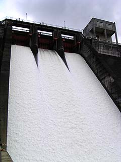
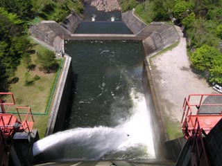
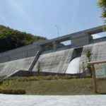
I'm sorry to those who said, "I'm not interested in watching a video" or "I don't want to watch a video! I am very sorry for those who say "I don't want to see a video" and for those who are in the narrow band, so I will also publish still pictures. The upper photo was taken from the right bank on the downstream side, and the lower photo was taken from the embankment. Every time I go to Habu Dam, there is a drought, and I have never seen such a discharge before. Moreover, water was discharged from all the gates. (Added on 9/3/2003)
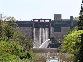
View of the levee from the bridge at Koukoi-no-Sato, located downstream
A series of dams that are close by but not often covered? Habu Dam is one such dam in this series. To approach the dam, from the Nagoya area, take Route 153 through Toyota City to Route 301. If you continue on through to Shimoyama Village, you will be able to reach the dam quickly as there are signs everywhere.
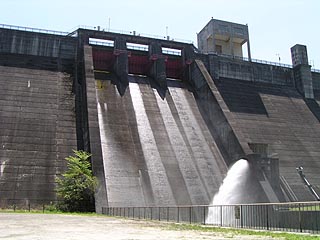
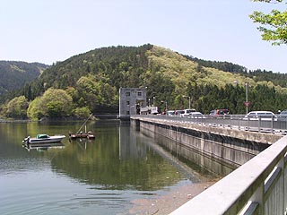
View of the levee from the plaza below the levee
The area near the dam has become quite a tourist attraction, and the Shimoyama Village has developed a tourist and recreational facility called "Kokoi-no-Sato". In addition, fishing can be enjoyed on the dam lake, and boats are available for rent.
On holidays, there are a great number of tourists due to the recent recession. Although it was Golden Week, many of the cars stopped in the area had license plates with Nagoya numbers, with Mikawa at the top of the list.
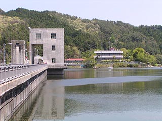
View of the dam lake from the levee (right bank)
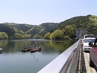
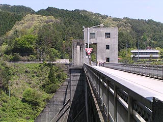
View downstream from the levee (right bank)
View of the embankment (lake side) from the right bank
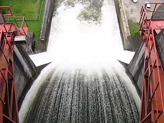
View of the flood discharge from the top
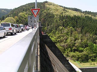
View of the levee (downstream side) from the left bank
View of the embankment (lake side) from the left bank
dam characteristics
| Model | Straight overflow concrete gravity dam |
| Objective | outside the control or jurisdiction (of) |
| Bank height | 62.5m |
| Bank length | 398.5m |
| Dam volume | 316,000m3 |
| Watershed Area | 51.3 km2 |
| Reservoir area | 106ha |
| Total storage capacity | 19,363,000m3 |
| Effective water storage capacity | 18,461,000m3 |
| Name of Dam Lake | Lake Mikawa |
| Roller gate for water intake | 4 gates |
| Flap gate for water intake | (one) gate |
| emergency flood gate | (one) gate |
| Flow control valve | (one) gate |
| Flood discharge structure | 3 tenter gates Width 7.5m Height 6.5m |
| momentum reducer | sub-dam Height 10m |
| Planned Maximum Water Withdrawal | 17.4m3/sec. |
| River Name | Yahagigawa River system Tomoe River |
| Year of launch | 1953. |
| Year Completed | 1962 |
Other facilities/observations
There is a parking lot, but all of them were full, so we parked at the top end. Come to think of it, this is the only dam where you can park at the top end. We had to go to the boat pier to use the restroom, but it was a bit far. It is strange that such a large dam, which has become a tourist attraction, does not have a PR exhibition hall. Is it because it is not a multi-purpose dam?
| Parking lot | ○ |
| Toilet | ○ |
| Park | ○ |
| PR Exhibition Hall | × |
Comment
Please tell us about the accident situation of those who died in the line of duty at the time of construction. I was deeply moved when I saw the cenotaph for those who died in the line of duty. I bow my palm in prayer.
>sakakibara
Unfortunately, we do not know the circumstances of the accident. However, I would like to express my gratitude for the sacrifices made by those people and for the fact that we are able to eat the crops produced by the farmers because the dam is used for irrigation.