
Location: Takayama, Iga City, Mie Prefecture
Date of interview: Wednesday, February 09, 2011
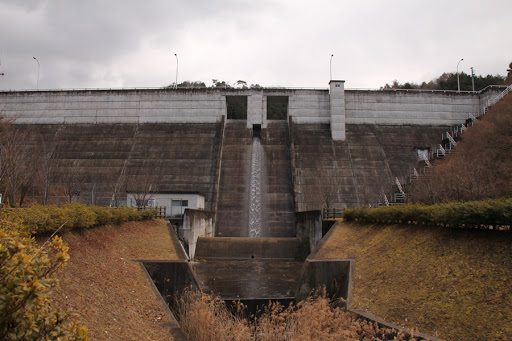
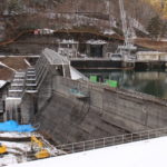
View of the levee from downstream
With nothing to do and no place to go, I decided to go to Iga. But it is not a ninja house. The purpose was to visit a dam. We arrived at the Takigawa Dam. Approaching from an empty main street, I caught a glimpse of the embankment at the end of a curve. It was a very quiet place because of the winter season.

View of the force-reducing structure from downstream
Taki River Dam is a gravity-type concrete dam built in the Takayama area of Iga City on the Taki River, a small branch of the Hijiki River, a branch of the Kizu River, a branch of the Yodo River system. The purpose of the dam is to provide a stable supply of 500m3 of water per day to the Hijiki, Surimi, and Takayama areas of Iga City by maintaining the river downstream with a flood control capacity of 12m3/s against a planned flood discharge of 20m3/s.

View of the emergency flood discharge from downstream
This is a very simple, cost-effective dam of the type often seen in prefectural dams. The crest is a free overflow type with two gates, and the orifice is also a free overflow type, although it has only one gate.

Looking downstream
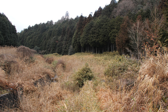
Downstream, the grass was all overgrown.
View of the levee from the plaza downstream on the left bank
The downstream side is a plaza and there is a pavilion as shown in the photo. However, I was not sure what kind of animal it was, but I noticed droppings here and there. Probably deer or something...

View of the levee from the plaza downstream on the left bank
The design looks monotonous due to the square emergency flood discharge.

View of the sub-dam from the left bank
The sub-dam seemed relatively large compared to the flood discharge.

View of the orifice
The screen on the dam lake side can also be glimpsed behind the orifice.

View of footing on left bank
The footings are impassable. Even if it were passable, I wouldn't think of going through it.

View of the abatement pond from the left bank
The reduction pool is also spacious. The hole in the back is probably a valve hole.

View of the levee downstream from the right bank
It had been raining until morning, so the rain-soaked embankment creates a nice atmosphere, but it is also somewhat gloomy because of the winter season. And no one is around...

View of the right bank from the left bank
As you can see, the top edge is closed to automobile traffic.

View of the flow-conducting section and force-reducing structure from the top edge
The part with the break in the revetment at the end of the reduction works is kind of cool.

View of the levee downstream from the left bank
The atmosphere, or rather the appearance, of this dam differs greatly depending on where you look at it. From here, it looks strangely like a hard gravity concrete dam.

View of the embankment from the left bank
We have reached the other side of the river. By the way, there is a light at the top edge. I wonder if this light is turned on at night.

View of the embankment on the lake side from the left bank
Crisp dam lake side. It is quite simple.

View of orifice screen
It is like a fence to prevent the gate from getting clogged with trash.

View of the dam lake from the left bank
It is a narrow dammed lake. It is so small that you can easily see upstream.

View of the embankment on the lake side from the left bank
The season is February. Can you see a thin layer of ice on the dam lake?

View of the dam lake and the right bank from the left bank
I remember it was a very cold day, partly because it had rained.

View of the emergency flood discharge from the left bank
The square emergency flood discharge looks a bit unsightly. Well, I guess it is not about design but about function....

View of the dam lake and embankment from the left bank
At my son's suggestion, we decided to go around the dam lake. My son, who is a spoiled child, immediately asked for a piggyback ride or a cuddle, so I was reluctant to do so...

View near the end of the dam lake
Even if you walk slowly, you will soon be able to move upstream.

View of the erosion control dam at the inflow
Water from the stream flows through an erosion control dam like this one.

View of the dam lake and embankment from upstream
It was completely cloudy when we arrived, but it gradually cleared up.

View of the administration office
It is a management office, but it seems to be usually unmanned. It seems to be well built, but I wonder if they are trying to cut costs.

Distribution of Dam Cards
Therefore, you have to go to Iga City Hall to get a dam card. By the way, is a dam a "visit"?

laying a cornerstone (foundation stone)
Oh, a cornerstone in that place! The cornerstone was a little bit crudely treated with a basket on top of it.

Takigawa Dam Specifications
| River Name | Yodo River System Taki River |
| Objective | Flood control, agricultural disaster prevention, unspecified water, river maintenance water, water supply water |
| Model | gravity-fed concrete dam |
| Bank height | 29.8m |
| Bank length | 120m |
| Dam volume | 30,000m3 |
| Watershed Area | 1.6 km2 |
| Reservoir area | 4 ha |
| Total storage capacity | 282,000m3 |
| Effective water storage capacity | 230,000m3 |
| Dam operator | Mie prefecture (Kinki area) |
| Main body constructor | Obayashi, Nippon Construction, Horiike Gumi |
| Year of launch | 1990 |
| Year Completed | 1999 |
Other facilities/observations
It looks like it was set up for visitors to tour and I don't think there was a bathroom. Just a hazy memory so sorry if I'm wrong.
| Parking lot | ○ |
| Toilet | × |
| Park | ○ |
| PR Exhibition Hall | × |
| Fishing | ×x? |
Accommodations that may be close to Takigawa Dam
Comment