
Location: Umechi, Honkawane-cho, Haibara-gun, Shizuoka Prefecture
Official Web site:.http://www.cbr.mlit.go.jp/nagashima/
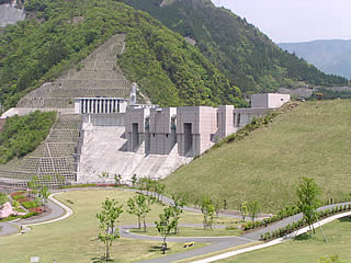
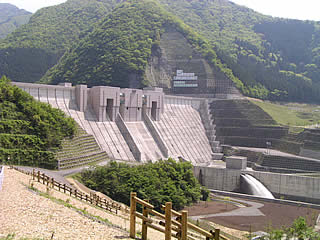
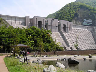
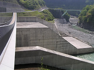
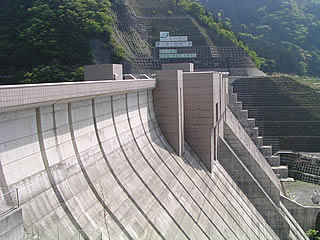
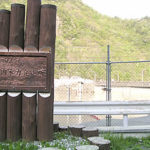
View of the levee (downstream side) from the left bank

As a "dam open to the community," the Nagashima Dam is more open than most dams. I knew the name of the Nagashima Dam, but I did not do much research beforehand, so I had no idea that there was so much to see and do. I would recommend that you allow plenty of time for your visit.
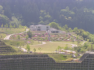
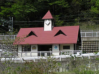
Nagashima Dam Fureaikan
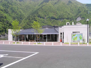
Before approaching the embankment, we first went to the "Nagashima Dam Fureai Kan" to learn about the Nagashima Dam.
Ayu Noboribori (ayu fish?) Ayu fish (rockfish? mountain lionfish?)
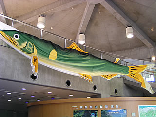
As we entered, the staff of the exhibition hall spoke to us in a friendly manner. As we proceeded to the back, he pointed to the ceiling and said, "Look at this! It's not a carp streamer, but an ayu fish streamer. Ha ha ha!" He laughed loudly. He was so strangely excited that I reacted in a strange way, saying, "Oh, it's true! It was displayed because it was close to the May festivals, and he really wanted to see it.
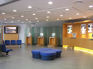
Inside the museum (local information corner)
While moving around the museum, we asked how we could get to the dam at the end of the forest road. He replied, "The forest road is not closed to the general public, but it is in a state of disrepair, so I am not sure.... I can't say for sure because the jurisdiction is different," he said. He seemed to be aware of the Japanese hostage crisis in Iraq, and said, "Yes, that's a popular word now! It's a popular word right now! He replied, "It's a popular word right now! He is a talkative and joking staff member. While joking, he was very kind to us, even bringing us a sightseeing map of the neighborhood.
Inside the museum
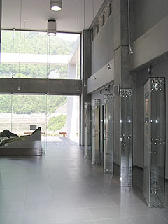
The overall transparency of the space creates a bright and clear image. The method of displaying panels made of acrylic is also unique.
Model dam
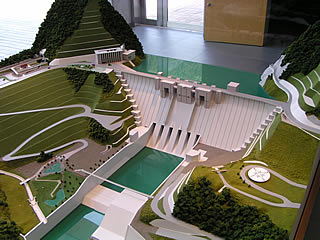
When I see a model, I always take a picture of it even though the real thing is there. It is still a very well-made model.
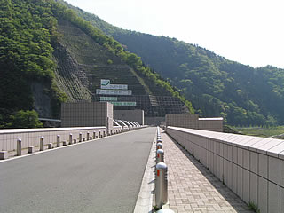
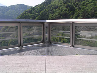
Control center (?) from right bank (downstream) from the right bank (downstream side)
After leaving the Fureaikan, we finally reached the dike. The Fureaikan is on the left bank, and we tried to go around to the right bank, but the staff at the Fureaikan told us that the top edge is "basically" closed to cars. In fact, cars are allowed to pass through (we saw some cars passing by), but we followed the staff's advice and went around the downstream side of the river without passing through the top edge, and then moved to the right bank.
View of the embankment from the right bank (downstream side)
There is a park directly below the embankment, where you can look up at the dam from downstream. However, it is only possible to go directly downstream on foot. And the distance is very long. I thought that I should have moved from the Fureai-kan on the left bank, but I had no regrets. We had no choice but to go down on foot.
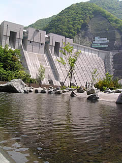
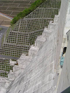
View of the levee from the downstream right bank
Out of breath, I came to just below the embankment. It may be difficult to get a sense of the atmosphere from this photo, but the embankment is quite large. It is very rare to be able to see the dam from directly below, so I took many pictures.
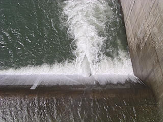
View of the Splash Bridge from the park on the downstream side of the right bank
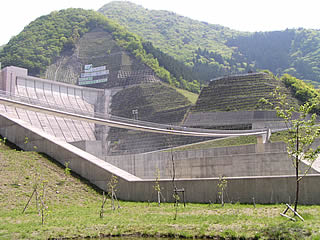
This bridge is also known as the Splash Bridge. The droplets of water discharge for water utilization do indeed fly over it. However, it would not be enough to be splashed from the flood discharge.
By the way, there are several people in the middle of the bridge. Can you compare the size?
View of the levee and splash bridge from the park on the downstream side of the right bank
I photographed the bridge and the embankment. Anyway, it is so huge that it is hard to capture it in a subject.
View of the levee from the park on the downstream side of the right bank
Hmmm, failure...
I tried to get a good shot of the pond and the bank....
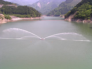
View of the irrigation water discharge from the Splash Bridge
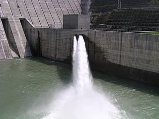
The water is discharged for water utilization. I was careful not to get splashed by the camera. There seem to be two discharge pipes. Even though this is a water utilization discharge, it is still very powerful.
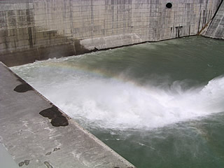
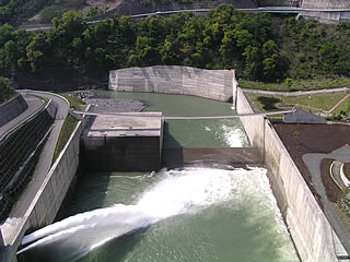
View of the overflow from the sub-dam from the Splash Bridge
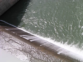
This is the overflow from the sub-dam.
View of the overflow from the sub-dam from the Splash Bridge
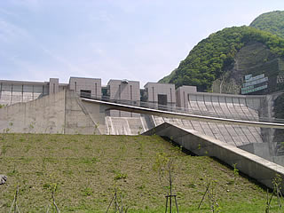
View of the levee from the Splash Bridge
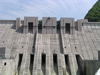
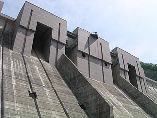
Discharge capacity 995m3It is equipped with six /s permanent flood discharges and four emergency flood discharges, making it look like a giant battleship.
View of the Igawa Line from the Splash Bridge
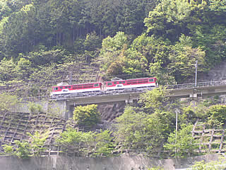
Suddenly, I looked behind me and saw an Igawa Line train running with its whistle blowing. The train running from Apto Ichishiro Station to Nagashima Dam Station is an Apto-type train, which is a rare type of train that has a third rail in the middle of the track with jagged teeth like those of a saw, on which the locomotive runs by meshing gears. It is said to be the only one of its kind in Japan. It is said that the track was deliberately replaced because a section of the Igawa Line was submerged due to the construction of a dam. The steep gradient made it impossible to run the line normally, so they decided to use an apt-type train. A full telephoto was utilized for photography.
View of the levee from the Splash Bridge
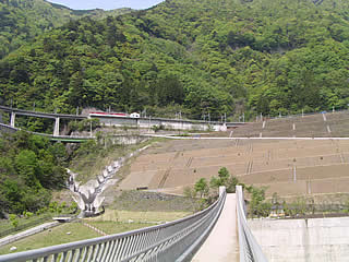
An Igawa Line train just arrived at Nagashima Dam Station.
Overall, it looks like this. You can see that the railroad runs at a fairly high elevation. The curved bridge creates a mysterious space.
View of the rainbow from the Splash Bridge
The water from the irrigation discharge was making a faint rainbow, so I couldn't help but take a picture of it. Well, photographing rainbows is difficult... (sweat)
View of the levee and water discharge from the Splash Bridge
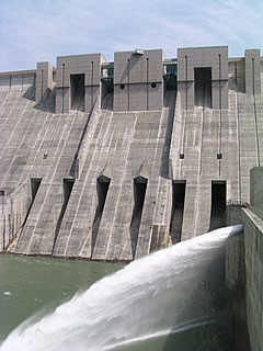
Two shots of the levee and the water discharge. It must be great if the water is discharged from the flood discharge. I would love to see it.
View of the sub-dam from the Splash Bridge
The structure of the sub-dam is also unusual. This may be the first time I have seen such an unusual sub-dam. The Oi River turns left and flows from the sub-dam.
I heard that there is an Oigawa dam ahead, but I could not find it....
Old Line Tunnel on the Igawa Line
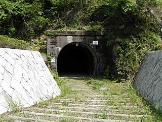
As mentioned earlier, the Igawa line has been rerouted due to the construction of the Nagashima Dam. The tunnel of the old line is located just below the embankment, and visitors can go through the tunnel to go directly under the real embankment.
This is a bit impressive.
View of the embankment from the exit of the old line tunnel
When we passed through the tunnel, we were not in snow country, but in an embankment!
To be able to see directly below the 100-meter dam at such close quarters....
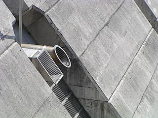
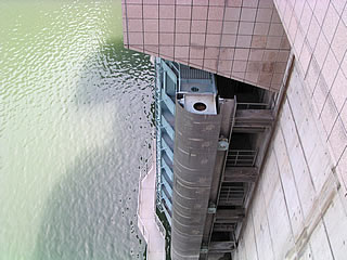
Discharge pipe (?) from mid-footing from the middle of the footing
You can also climb up to the footing. Although there were several more dams to cover after this, I took the plunge and climbed up the footing without worrying about my fitness.
We climbed up the embankment, looking right at the side. It takes time, taking a break when you get tired...but we managed to do our best.
Looking casually to the right, I saw something that looked like a discharge pipe, which I could not tell whether it was for emergency or regular use. However, it is not clear what it is for.
View of Fureaikan from the footing
We are one step closer to the top edge.
Looking across the river, the Nagashima Dam Fureaikan can be seen in the distance.
View of the levee (downstream side) from the right bank of the top end
Well, we finally reached the top of the mountain. I can't tell you how many times I had to take a break to get to this point. It is a beautiful and huge dam.
View of the lake monument
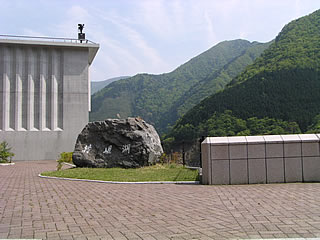
There is a stone monument at the right bank dam site that reads "Lake Precipice. It reads "Sessai" (せっそこ). There is a gorge called "Sessai Gorge" in this area, and it seems to have been named after it.
View of the embankment (lake side) from the right bank
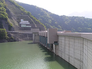
The dam lake side is beautiful and massive in shape.
View of the top edge from the right bank
As mentioned earlier, the top edge is "basically" closed to vehicular traffic. I am not sure why it is prohibited, but I don't think there is any particular need to prohibit it. Could it be due to terrorism...?
View of the gate from the top
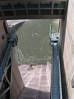
It is quite high, but compared to the arch-type Yahagi No. 1 Dam, which has a lower embankment height than the Nagashima Dam, it did not seem so high. Perhaps the arch-type dam feels higher because of the overhang.
You can see what appears to be a crosswalk over there. Is it a corridor for operating each gate?
View of footing from top edge
This is the footing I just climbed. I am not sure if I will ever make it this far in the future, as I am not confident in my physical strength...
The area around the dance floor is wet, but this is because the rainwater flowing through the gutters was stopped by accumulated debris, and because I cleaned the gutters a little (?), the water flowed out vigorously. I cleaned out the gutters a little and the water flowed out. I did a little work in dam management.
There were no people under each dance floor, so don't worry about that.
View downstream from the top
This is the view from the center of the top edge. It looks like a child's toy box or sandbox. Looking at the photo, I suddenly remembered me as a child playing in a sandbox. Seeing me building roads and other structures in the sandbox my father had made at home, my grandmother once asked me, "Will you be a construction worker in the future?" She once asked me, "Will you be a construction worker in the future? Unfortunately, at the time, I didn't have the slightest idea of such a thing, but I had no idea that I would develop an interest in "huge buildings" as an adult. If I could throw away my shame, I would probably build a dam now.
Viewing terrace (downstream side)
This isTop (Crest)(Downstream side) This is the observation terrace-like area located in the center of the dam. The floor is grating, so you can see directly under the dam from your feet.
View of the dam lake from the top (downstream side)
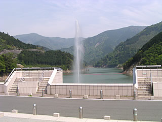
There is also a terrace on the dam lake side. It offers a panoramic view of Lake Precipice. On the other side, there is a fountain that seems to be for surface aeration.
View of the surface aeration fountain from the top
This fountain blows up in various forms over time. It is a mechanism that one never gets tired of seeing, but perhaps the reason it blows in various forms is not just for show.
View of the gate of the permanent flood discharge from the top
This is a gate for a permanent flood discharge. It looks like a roller gate, but is it? By the way, the emergency flood discharge is almost certainly a radial gate.
View of the surface aeration fountain from the top
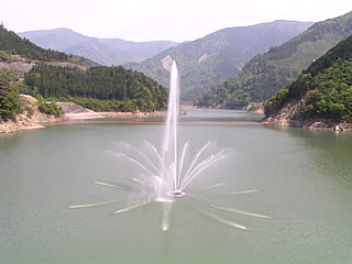
When I looked at the fountain, I saw that the shape had changed again, so I immediately took a picture of it. The fountain is really gorgeous (?) because it is not monotonous. It really is a gorgeous fountain.
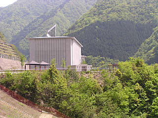
View from the top of the building View from the top
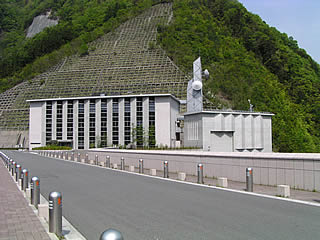
The presence of parabolic antennas and other equipment suggests that it is probably a control station. The scale of the building is so large that it is probably used for other purposes as well.
Nagashima Dam Station
Now, we leave Nagashima Dam. The picture on the left is Nagashima Dam station in the Igawa line. It is a small and cute station building. It is the newest station building in the Igawa line, and it was built when Nagashima dam was constructed.
Also, stations named after dams are very rare. In Japan, there are only a few that can be counted on one hand. Conversely, Nagashima Dam is a dam that can be visited by public transportation.
dam characteristics
| da mu | Model | gravity-fed concrete dam |
|---|---|---|
| Objective | Flood control, agricultural disaster prevention: unspecified water, river maintenance water Irrigation water: Water for water supply | |
| Bank height | 109m | |
| Bank length | 308m | |
| Dam volume | 861,000m3 | |
| savings water (esp. cool, fresh water, e.g. drinking water) pond | Watershed Area | 534.3 km2 |
| Reservoir area | 230 ha | |
| Total storage capacity | 78,000,000m3 | |
| Effective water storage capacity | 68,000,000m3 | |
| Name of Dam Lake | Precipice Lake | |
| River Name | Oigawa River System Oigawa River | |
| Year of launch | 1972 | |
| Year Completed | 2001 | |
| Access to D@M | Get off at Sagara Makinohara IC of Tomei Expressway The rest of the way is National Route 473 heading north toward Kawane Town. After entering Kawane Town and eating taiyaki at Ieyama, head north again on Route 473. After driving for a while, you will hit a T intersection with Route 362. Turn right at the intersection and go north on Route 362. There is a road that enters Prefectural Route 77 near Chigashira, so turn onto that road and continue north. When you pass the Okuizumi station in the Igawa line in the railroad, you will see the fork of the Sunmatakyo and the Precipice. Turn right onto Prefectural Route 388 toward the precipice. After passing through two tunnels, the Nagashima Dam is already in front of you. | |
Other facilities/observations
| Parking lot | ○ | There are indeed many dams in the area. Among them, Nagashima Dam is a dam with a great deal to see. There were a number of dams that I could not see at all, so I feel as if I dissipated that here. This is why this site is now larger than ever before, with five pages. As an aside, the sansai soba (buckwheat noodles with wild vegetables) at Benitake Shokudo in Sunmatakyo was very tasty. |
|---|---|---|
| Toilet | ○ | |
| Park | ○ | |
| PR Exhibition Hall | ○ |
Comment
[Auto-post] DamPedia Archives - Please take a look when you are free - 1178 - Nagashima Dam / Nagashima Dam http://t.co/fAHMSeYu4n