
Location: Touri, Nanto City, Toyama Prefecture
View of the embankment from the right bank (dam lake side)
")
Normally, one would go to this dam from the center of Fukko Town, but this time we took the narrow and steep Prefectural Road No. 54 all the way from Kamidaira Village. The reason why I went all the way is because I like narrow roads, but thanks to this, my car is covered with branches and scratches.
View of the lake bottom from the right bank (dam side)
")
The bottom of the lake is completely visible, perhaps due to the drought. Looking at the lower side of the photo above, we can see the remains of a foundation that looks like a house. The photo on the left is an enlarged image of the ruins. I wonder if there used to be a village in this dammed lake...
View of the lake bottom from the right bank (dam side)
")
Furthermore, looking at the bottom of the lake from other angles, we can see what appear to be the remains of stairs and fields. The stairs are also wide across, suggesting that they may be the remains of a shrine or temple.
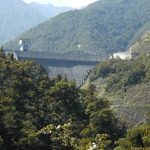
View of the embankment from the right bank (dam lake side)
")
Little by little, the levee is getting closer.
Zoom in on the levee

I think it is the part that controls the gate of the flood discharge, but it is a very strange shape. It's cute or funny....
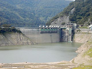
View of the embankment from the left bank

The height of the embankment is quite high, and the arched shape makes it feel wonderfully tall. The orange catwalks are also very unusual.
dam characteristics
| da mu | form (something takes) | arched concrete dam | |
|---|---|---|---|
| Objective | Irrigation water and power generation | ||
| Bank height | 101m | ||
| Bank length | 229.4m | ||
| Dam volume | 148,000m3 | ||
| savings water (esp. cool, fresh water, e.g. drinking water) pond | Watershed Area | 45.9km2 | |
| Reservoir area | 103 ha | ||
| Total storage capacity | 31,400,000m3 | ||
| Effective water storage capacity | 23,400,000m3 | ||
| River Name | Oyabe River, Oyabe River System | ||
| Year Completed | 1966 | ||
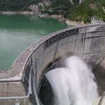
| casting off one's attachments (in Zen) method of facilities equipment | Flood discharge gate | Model | overflow damming ceremony |
| Dimensions | 8.2*2.9*6 gates | ||
| capacity | 435m3/s | ||
| Howell Vanger Valve | Model | Air diffusion type | |
| Dimensions | Inner diameter 1,350mm | ||
| capacity | 30.0m3/s | ||
| last performer of the day (usu. the star performer) water (esp. cool, fresh water, e.g. drinking water) gate | Model | inclined plane | |
| Dimensions | Height 52.0m, width 7.0m | ||
| gate | Height 8.3m, width 4.0m | ||
| guidance water (esp. cool, fresh water, e.g. drinking water) the way (of proper conduct, etc.) | Model | Circular Pressure Tunnels | |
| inside diameter | 2.80m | ||
Other facilities/observations
| Parking lot | ○ | At the end of the first day of coverage of the dam I went on a trip to Kanazawa. I was happy to have found this dam. It was almost dusk, so we went to "Usunaka Dam" near Touri Dam and We had to abandon the "Saikawa Dam" and the "Uchigawa Dam. But after covering the Touri Dam, we're headed to Kanazawa. When entering Ishikawa Prefectural Road 10 from the Touri Dam. On a 1km long gravel road (and a steep slope) It was nothing but a bad road. There were strong people (and a couple) who tried to go down such a bad road by "bicycle. It is an interesting road, but I remember it was a "steep road" not a prefectural road because it was very bumpy. |
|---|---|---|
| Toilet | ○ | |
| Park | × | |
| PR Exhibition Hall | × |
Comment
My name is Inaba, and I work at a community center in the Taibi Mountain area, a district that includes Touri.
This year will mark 50 years since the village left the lake due to the construction of the Touri Dam, so we are now gathering information about the village that sank to the bottom of the lake.
Therefore, we would like to use the top three photos from this page for publicity and information dissemination within the district.
I know you are busy, but I would appreciate a reply.
>Mr. Inaba
Thank you for your comment.
I have emailed you directly and would appreciate it if you could refer to it.