

Location: Shigetagawa, Naha City, Okinawa
Date of interview: 2010/05/20
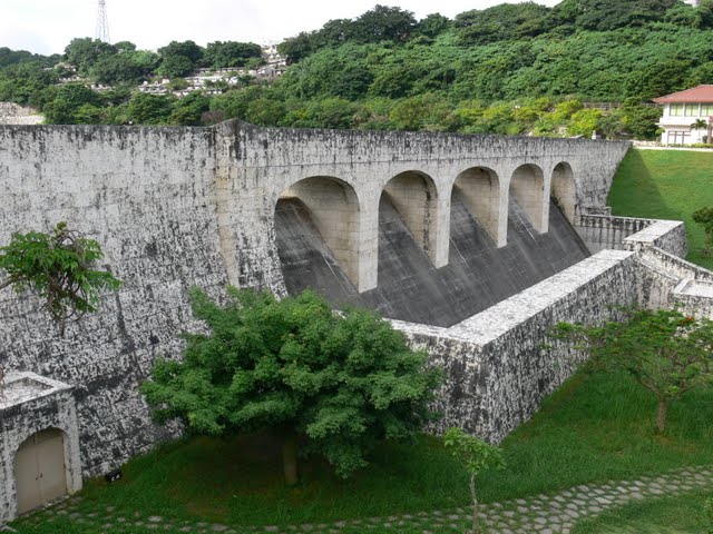
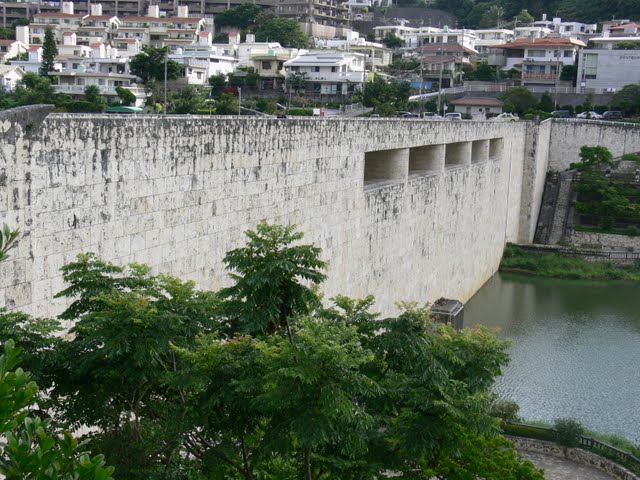
View of the levee from the downstream side of the right bank
The third and final day of the Okinawa tour. Since we were staying in Naha City on the last day and were to meet at the airport at 10:45 a.m., we decided that this dam would be the best place to go. I thought I would be able to make it here in time.
So I woke up at 6:30 a.m., had breakfast at the hotel at 6:45 a.m. in 15 minutes, and left the hotel a little past 7:00 a.m. I took the Yui Rail (monorail) departing from Asahibashi Station at 7:21 a.m. and arrived at Shuri Station at 7:38 a.m. From there, I walked for about 15 minutes while letting Google Maps navigate me. From there, I walked for about 15 minutes while letting Google Maps navigate on my iPhone. I was tired from the unfamiliar terrain, but I finally arrived at the station, being greeted by elementary school students on their way to school.
Morning is good.
It was such a refreshing experience to feel such an Okinawan dam.
Hmm? Is that a cornerstone?
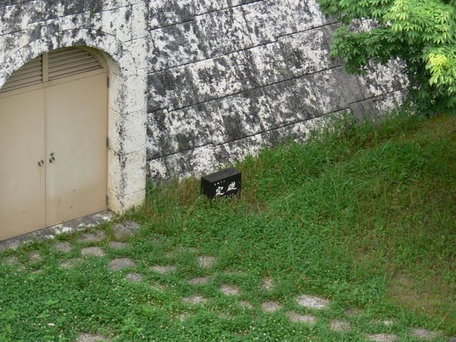
I was curious about this cornerstone as soon as I arrived. It was handled in a messy manner.
View of the top edge from the right bank

Maybe because it was morning, there were many people walking alone, or with their dogs, or whatever.
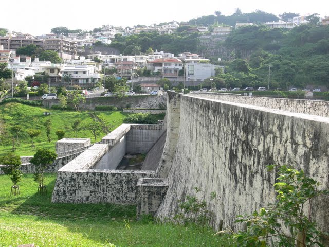
View of the dam lake from the top

The dam lake of the Kinjo Dam has an upper pond and a lower pond, and what you see in the back is a tunnel connecting them. I wanted to go to see the other side of the dam, but had to cut it off due to time constraints. I wanted to go to see the other side of the dam, but I had to cut it off due to time constraints.
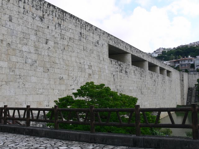
View of the embankment from the downstream side of the right bank
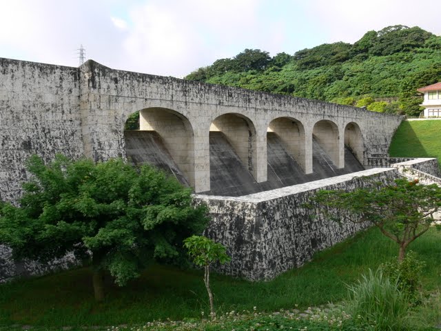
The embankment is made of Ryukyu limestone, a material unique to Okinawa. It is the very wall of Shurijo Castle. It is said that the design was inspired by the nearby Shuri Castle.
laying a cornerstone (foundation stone)
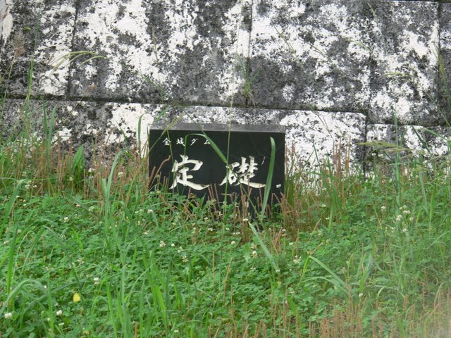
The foundation stone sits in the grass....
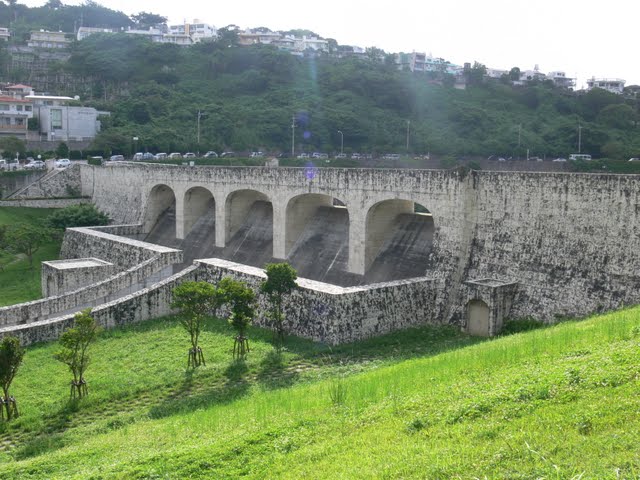
View of the levee from the bridge downstream

Oops, I was in a hurry for time, so I was oblique. The Ryukyu limestone as well as the blackened areas have a nice taste.
And how thick and high the conduit wall is compared to the embankment. It reminds me of the outer wall of Shuri Castle. Personally, however, I think it would have been better if the embankment had been colored a little more "Ryukyu red," a color unique to Okinawa.
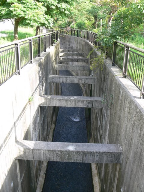
View of the conduit from the bridge downstream

The downstream side seems to be made of ordinary concrete. It was probably due to cost reasons that they could not use Ryukyu limestone for the entire length of the channel.
View downstream from the bridge
The river is unusually narrow. Because of this, the river has often suffered from flood damage when it rains heavily. The river flows through the center of Naha City and Kokusai-dori Street, so it is easy to see how important this dam is.
View of the levee from the downstream side of the left bank
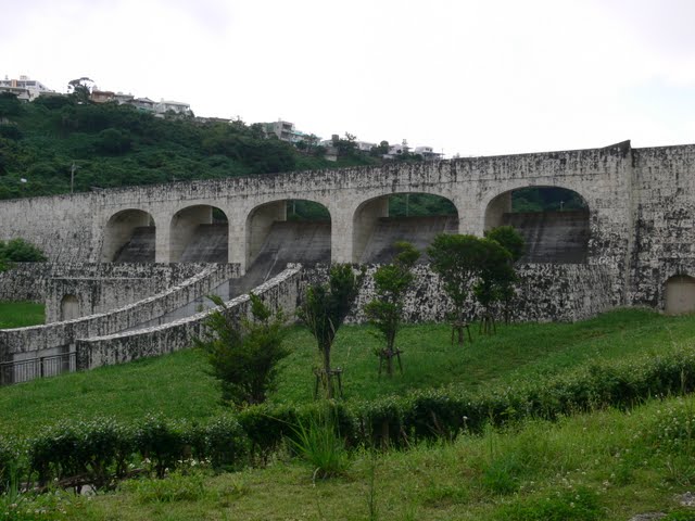
After all, this figure is like a castle wall.
Shuri Castle, by the way, is a castle with a design that is completely different from that of mainland castles, and has Chinese elements.
View of the levee from the pavilion on the downstream side of the left bank
The road over there is a prefectural road, but it was congested throughout the shoot. It was a line of cars on their way to Naha City for work. I thought there were no traffic jams in Okinawa, but I was surprised at this. The only train is the Yui Rail monorail (and its operating distance is short), and the only other public transportation in Okinawa is buses, so it is impossible to live without a car.
View of the levee from the downstream side of the left bank
See, this is massive! It may rarely flow from the crest, but not only does the dike protect it, but the conduit wall protects it even more! That's the image I get.
View of the tunnel connecting the upper and lower ponds
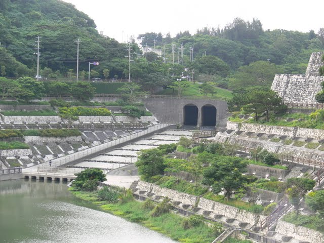
If I had had more time, I would have liked to take a closer look at that area, but I had to look at it from a distance.... I am very anxious to see it, but I had no choice.
Incidentally, thickly growing on the dam lake shore are mangroves.
administration office
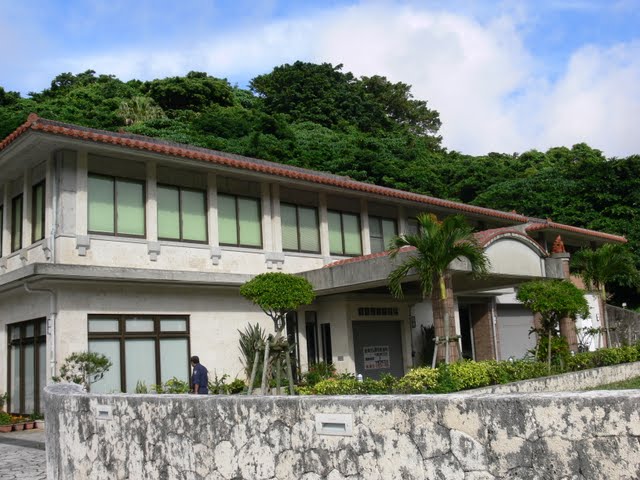
This is a very Okinawan-style management office. The roof seems to be made of Ryukyu tiles. There is also a Shisa. Shisa is said to be the guardian god of Okinawa, and you can see them everywhere in Okinawa.
They have an exhibition room in the administration office where you can also watch documentary films. The museum is open from 9:30 a.m. to 5:00 p.m. and is open on Saturdays and Sundays. Unfortunately, we could not visit the museum because we would have missed our flight if we had waited until the opening hours...
View of the dam inscription and the embankment

A quick snap of the monument and the dike.
View of the embankment from the left bank of the dam
The front is sleek and not too stark.
View of the dam lake from the top of the left bank
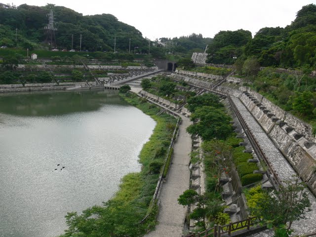
It is a very complete dam lake and dam lakeside. I wanted to take a long walk to the back.
Since the dam is designed for flood control, if it has to work at full capacity due to flooding, this place will be submerged, just like the Tenno Dam (1507-Tenno Dam/Tenno Dam).
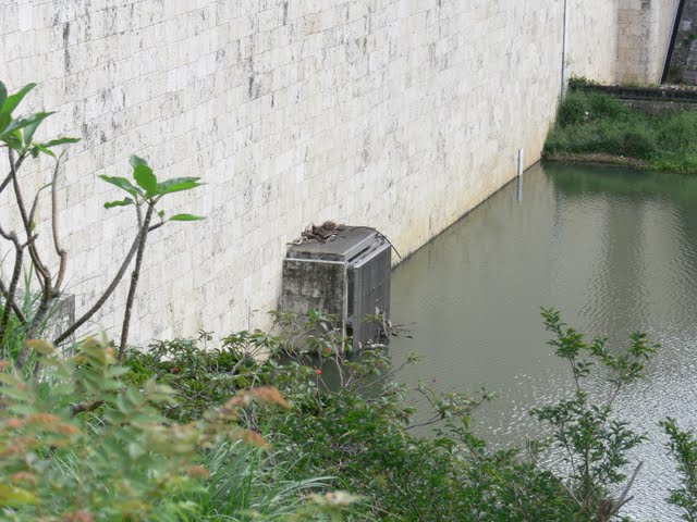
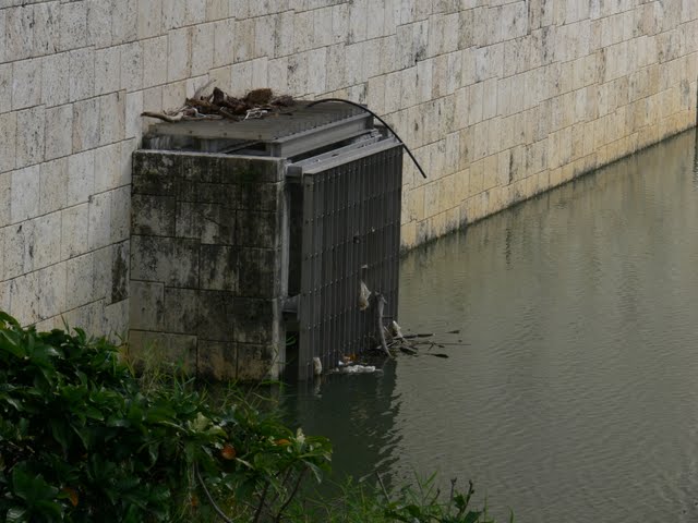
View of orifice gate
The construction of this area is similar to that Tenno dam.
Close-up of orifice gate
View of the embankment from the dam lake side
It is rather taller from the dam lake side than from the downstream side. And the atmosphere of this Ryukyu limestone stone lining is really good.
Dam lake side wall

I got even closer.
Hub attention!
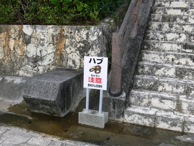
This is a warning sign that you will never see in the mainland. It was so rare that I couldn't help but snap a picture. And I wanted to climb up these side stairs, but I didn't have time and I was afraid that I might really get a hubby... (sweat)
View downstream from the top

You can see the thickness of the conduction wall even more from here. Hmm? What is that structure in the lower center? I didn't pay attention to it when I was taking this picture...
View of the city downstream from the top
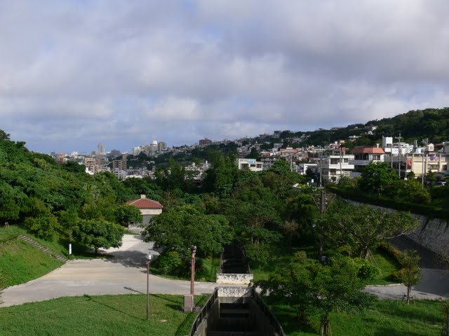
Ahead of us is the center of Naha City, which is to be protected by the Kaneshiro Dam. I would have liked to take more time to look at this scenery itself, but unfortunately it was time to go. I left the dam for the last time.
Then we climbed the high ground on the right bank and went back the way we came, but I can't tell you how many times I tried to call a cab on the way. I can't tell you how many times I tried to call a cab on the way......and the cab that happened to pass by didn't stop....
I would like to train my legs and back more in preparation for future dam tours....
dam characteristics
| River Name | Asato River system Asato River |
|---|---|
| Objective | Flood control, agricultural disaster prevention, unspecified water, river maintenance water |
| Model | gravity-fed concrete dam |
| Bank height | 19m |
| Bank length | 120m |
| Dam volume | 14,000m3 |
| Watershed Area | 1.7km2 |
| Reservoir area | 4 ha |
| Total storage capacity | 510,000m3 |
| Effective water storage capacity | 470,000m3 |
| Dam operator | Okinawa prefecture (including Okinawa island) |
| Main body constructor | Takenaka, Marumoto |
| Year of launch | 1983 |
| Year Completed | Year 2000 |
Other facilities/observations
| Parking lot | ○ | It's the most substantial dam on this trip to Okinawa, but... The stay is still insufficient, lasting only 30 minutes. I would have liked to have seen more of the upper pond and inside the administration office. |
|---|---|---|
| Toilet | ○ | |
| Park | ○ | |
| PR Exhibition Hall | ○ | |
| Fishing | × |
Comment