
Date of interview: Sunday, July 3, 2011
Location: 185-2, Aza-Daikokuya, Onogami-go, Shogawa-cho, Takayama City, Gifu Prefecture
Meeting place, Hirugano Kogen Ski Resort

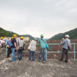
(I am very sorry to say that this was 6 years ago.) Power Development kindly allowed us to visit Daikokuya Dam and Hakusui Dam, which were originally off-limits to the public. The meeting place was at the Hirugano Kogen ski resort.
In the photos, you can see glimpses of people we can no longer meet and the cars they used to own.
Daikoku Valley Forest Road Gate

The Daikokuya Dam, which we are aiming for, is located at the end of a forest road that is closed to traffic.
Daikoku-dani forest road opened!

Finally, the forbidden gate is opened.
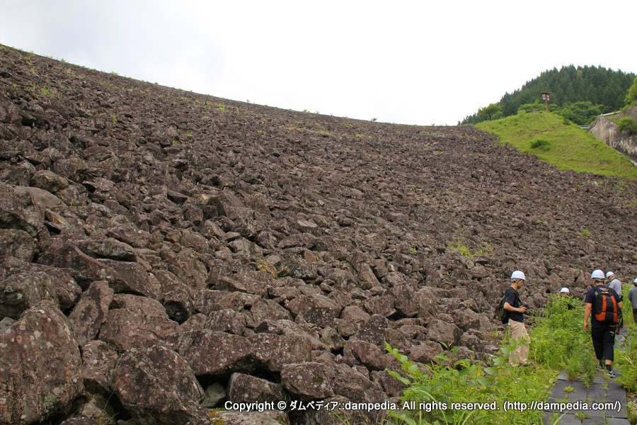
View of the levee downstream from the right bank

As you continue along the forest road, the embankment suddenly appears. The riprap is blackish, as is typical of rockfill dams in this area. It is also noteworthy that the embankment has a large curve.
View of the dam lake from the top

The dam lake is very beautiful because there are no houses or anything upstream. It is also very quiet.
View of the top edge from the right bank

There is no fence or anything at the top edge because it is not intended for people to pass through.
Daikokuya Dam stone monument and Power Development Patrol Car

A Toyota Surf and a Prado were the patrol cars. The forest road was paved, but I think they expect it to be rough. It looks like there is a lot of snow. However, this dam is not accessible by car in winter (see below).
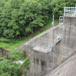
View of the conduit from the right bank

The conduction wall does not seem very high.
View of the water intake from the right bank

Water taken in by this building is sent to the power plant. This building also serves as a control center, which is usually unmanned but is used in emergencies, such as when a road collapses and it is impossible to return to the site. The building is also stockpiled with food for this purpose.
Discharge outlet where water flows into the dam lake

Water taken from the surrounding valley flows into the dam lake via this outlet.
memorial (stone)
")
The cenotaph stands quietly.
View of flood discharge

This is a fan-shaped free overflow flood discharge. Most of the water flows into the intake for power generation, so there may not be much flow from here.
Looking downstream from the flood discharge

This is a ski jump flood discharge.
View of the levee downstream from the left bank

The embankment is 34 meters high and the top of the embankment is 140 meters long, but it seems quite large.
Looking downstream from the left bank

Downstream is just nature itself. There are no sub-dams or reduction works.
What was I...

I think it was the entrance to the audit corridor... but it's been so long since the date of the interview that I forgot. w
View of the top edge from the left bank

This is a staff member of Power Supply Development who guided us around the site.
Chrysochroa fulgidissima

Caterpillars were walking on the top edge.
Top end structure

It was 6 years ago and I have completely forgotten what this was.... I think it is a structure to measure the distortion of the dike.... Sorry...
Shotgun shells...

Is the targeted prey a bear? Or is it a deer?
View of the top edge and no trespassing sign from the right bank

The top edge is off-limits. Rather, the forest road itself is off-limits.
Daikokuya Dam overview signboard

It is a very old sign. It may have been installed since the time of construction.
Discharge warning sign

Relatively new discharge warning sign. Even if it is off-limits, it must be installed by law. The assumption is not "no one will be there," but "someone might be there.
Now it's time to go downstream

We were allowed to look up the levee from the downstream side.
proceed through the jungle

The stairs descend like an animal trail.
View of the levee from downstream

It is wonderful that you are able to show us so much. Thank you very much.
lip wrap

This is a riprap with rough rubble masonry.
Downstream

There are traces of digging and leveling by heavy machinery. But how was it unloaded downstream?
View of the conduit wall from downstream

It is a valuable angle. Will we see it again in the future?
View of the levee and riprap from downstream

The arch is clearly visible from downstream.
Looking downstream

This is the tip of the ski jump.
structure directly under

The pathway is not for public tours, but only for patrols, so there is no foothold and no fence.
pennant

This dam cannot be reached by patrol car in winter because of deep snow. So what is done in winter is a helicopter. There is a helipad at the top end, and this streamer is for that purpose.
It was the kind of dam that is secluded and never accessible to the public, but where safety measures are taken....
Daikokuya Dam Specifications
| River Name | Shogawa River system Ogamigogo River |
|---|---|
| Objective | generation (e.g. power) |
| Model | Central soil barrier rockfill dam |
| Bank height | 34m |
| Bank length | 140m |
| Dam volume | 280,000m3 |
| Watershed Area | 64.6 km2 |
| Reservoir area | 9ha |
| Total storage capacity | 1,070,000m3 |
| Effective water storage capacity | 320,000m3 |
| Dam operator | Power Development Co. |
| Main body constructor | Ito-gumi Construction |
| Year of launch | 1969. |
| Year Completed | 1971 |
| Name of Dam Lake | - |
Other facilities/observations
Basically, all of them are x because they are prohibited to enter, but only fishing is marked as ○ because a no-fishing zone has been set up.
| Parking lot | × |
|---|---|
| Toilet | × |
| Park | × |
| PR Exhibition Hall | × |
| Fishing | ○ |
Comment