

Location: Takane-cho, Takayama City, Gifu Prefecture
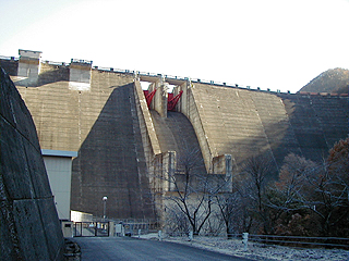
View of the levee from downstream
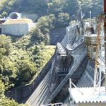
It can be found by driving National Route 361 east of Akigami Dam or west of Takane No. 1 Dam. The lower part of the dam is used for pumped storage power generation between the dam and Takane No. 1 Dam.
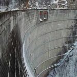
View of the embankment from the right bank

How pathetic... It is completely backlit. I'll go back and take more pictures next time.
dam characteristics
| form (something takes) | Hollow Gravity Concrete Dam |
| Objective | generation (e.g. power) |
| Bank height | 69m |
| Bank length | 232m |
| Dam volume | 162,000m3 |
| Watershed Area | 173km2 |
| Reservoir area | 58 ha |
| Total storage capacity | 11,927,000m3 |
| Effective water storage capacity | 5,785,000m3 |
| River Name | Kiso River System Hida River |
| Year of launch | 1963. |
| Year Completed | 1968. |
Other facilities/observations
It is an extremely closed dam.
The second photo would have been a little more decent without the fence....
そう言えば昔、勤めていた会社で「中電はお役所だ」と上司だったか先輩だったかがボヤいてました。まさにそんな感じです。
| Parking lot | × |
| Toilet | × |
| Park | × |
| PR Exhibition Hall | × |
Comment