
Location: Ibigawa-cho, Higashi Yokoyama, Ibigawa-cho, Ibi-gun, Gifu-ken
Official Web site:.http://www.cbr.mlit.go.jp/yokoyama/
In addition to the following, there is an article about a tour inside the Yokoyama Dam embankment!
→→Season for Familiarization with Forests and Lakes 2009 - Yokoyama Dam
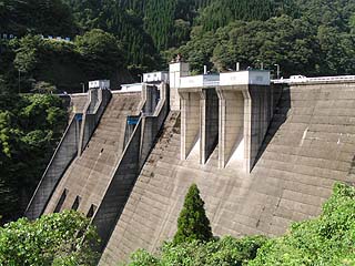
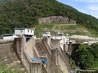
View of the levee from the parking lot on the downstream side of the left bank

Tokuyama Dam nearby.Under ConstructionBecause of its completion, the dam looks a bit shadowy. It is characterized by a relatively large number of gates. The three slits seen at the bottom of the embankment are orifice gates, and between them are two radial gates as crest gates on the left and right, and the two gates in front are probably gates for water intake for power generation, but these are all guesses.
View of the administration building from the parking lot on the downstream side of the left bank
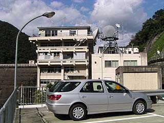
This is not my car, so please don't be sorry.... Below this parking lot is the dam manager's parking lot, and on the day of the interview, the manager was washing cars. I was going to ask about the gate, but he was washing cars so hard that I couldn't interrupt him...
View of the ledge from the parking lot on the downstream side of the left bank
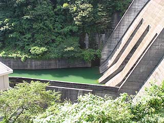
This is a close-up of the discharge port on the slit shown earlier.
View of the embankment from the parking lot on the lake side of the left bank of the dam
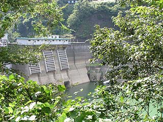
At this time, a rather suspicious-looking black luxury car was parked there, so I continued shooting despite the danger. It was a car with a license plate number from outside of the prefecture (Hokkaido or somewhere), and it was fully smoked. It was a little scary... But more than that, I couldn't see the embankment from here because of the trees and grass in the way. I decided to move to the other side of the river to take pictures.
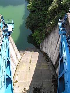
View of the top edge from the left bank
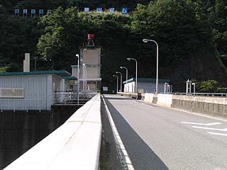
The top end is open to automobile traffic and is served by National Route 303. Beyond this point, passing through Bannai Village in Ibi-gun, Shiga Prefecture, you will reach Kinomoto Town in Ika-gun.
View of the power generation facility from the top
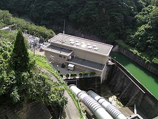
The "Yokoyama Power Plant" is attached directly under the dike and is said to generate up to 70,000 KW with two generators.
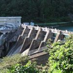
View of the emergency flood discharge from the top
We'll start with the gate on the left...
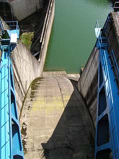
View of the permanent flood discharge from the top
And from the center...
View of the emergency flood discharge from the top
From the gate on the far right bank...
View of the Incline from the top
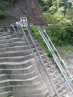
The incline is quite dilapidated. I am somewhat worried about whether it will work properly. The slope is quite steep.
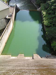
View of the dam lake from the top
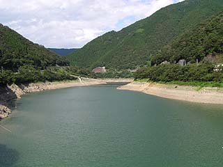
Ahead is the Tokuyama Dam. When completed, the environment will probably be somewhat different.
The Yokoyama Dam has been undergoing permanent sedimentation control since 1990, and after the completion of the work, the purpose of the dam will be added to the existing one: unspecified water, river maintenance water, water supply water, and industrial water, and the total water storage capacity will be 43,500,000 m.3Effective water storage capacity is 33,500,000 m3The information is being uploaded to the However, it was not clear from this interview where the construction work is being done.
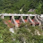
View of the embankment from the lake side of the right bank
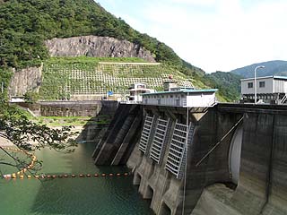
View of the levee from the downstream side of the right bank
dam characteristics
| Model | Hollow Gravity Concrete Dam |
|---|---|
| Objective | Flood control, agricultural disaster prevention, irrigation water, power generation |
| Bank height | 80.8m |
| Bank length | 220m |
| Dam volume | 320,000m3 |
| Watershed Area | 471km2 |
| Reservoir area | 170 ha |
| Total storage capacity | 43,000,000m3 |
| Effective water storage capacity | 33,000,000m3 |
| Name of Dam Lake | Lake Ibiko |
| River Name | Kiso River System Ibigawa River |
| Year of launch | 1957 |
| Year Completed | 1964 |
| Access to D@M | Get off at Ogaki IC of Meishin Expressway, and go north on Route 258, Turn left at the intersection with Route 21 and turn right at the Kawama intersection, Continue north on Route 417 and turn left at the Showa-machi intersection. Now we will continue north on Route 303. Passing through Kuse Village Hall and Kuse Dam, you will enter Fujihashi Village, and after a short while you will see it before your eyes. |
Other facilities/observations
Near the dam is a roadside station called "Hoshinohurusato Fujihashi," which is quite large. The toilets there are a bit strange. Most urinals are placed on the wall, but here they are placed in the center of the toilet.
In front of the urinal is a panel depicting the constellations of the zodiac, allowing visitors to study the constellations while doing their business...impossible!
| Parking lot | ○ |
|---|---|
| Toilet | × |
| Park | × |
| PR Exhibition Hall | × |
Comment
[...] We wanted to record this event with the full cooperation of the Japan Water Agency Tokuyama Dam (Tokuyama Dam on DamPedia) and Chubu Electric Power Co. The weather was fine until we entered the former Fujihashi Village, but it turned to sleet around Yokoyama Dam... and it snowed heavily at Tokuyama Dam! And although I had worn heavy clothes, I could not call them warm clothes. I was dressed in heavy clothes, but I was not very well protected from the cold! [...].