

Location: Toh-cho, Mizunami City, Gifu Prefecture
Official Web site:.Kozato River Dam Management Branch Office, Chubu Regional Development Bureau, Ministry of Land, Infrastructure, Transport and Tourism
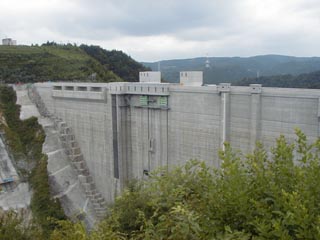
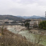
View of the embankment from the right bank
To get there, turn onto Prefectural Route 20 from National Route 19 or National Route 363, and pass through the Korijo Bridge on Prefectural Route 33.
Although Prefectural Road 33 was probably built for the construction of the dam, the Korijo Bridge is built very high and, like the dam, is worth seeing.
The dam itself is under construction as of August 2002 and is scheduled for completion in 2004.The following is a list of the most common problems with the
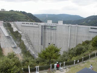
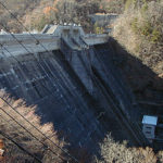
View of the levee from the observatory on the roof of the administration building
It is a rather large dam, but after its completion, as a "dam open to the community," the inside of the embankment will be open to visitors and the area around the dam will be a place for recreational activities. It is a very promising dam.
The dam is also active in publicity activities, with pamphlets freely available in the administration building and a lady at the reception desk. There are also games for children and a large monitor showing an introduction to the dam.
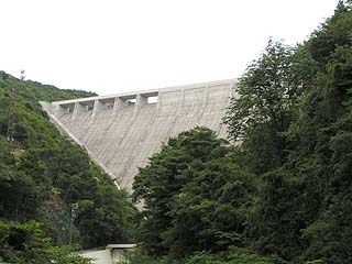
View of the levee from the downstream side of the right bank
From National Route 19, go south to Prefectural Route 20, pass under the Kori River Bridge, and turn left to see the downstream side of the levee. Be careful, however, as it dead-ends at the end.
The Kosatogawa Dam Lake Festival 2002
The dam embankment is located behind this.
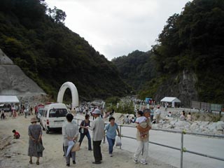
On Saturday, August 24, 2002, the "Ozato River Dam Lake Bottom Festival 2002" was held around the Ozato River Dam. I went to the bottom of the lake because it is not so often that I have a chance to visit the bottom of a dam. I would like to say that I felt a little sentimental when I thought that the place where I am standing now is about to sink, but I was too busy smacking my tongue over grilled beef skewers and mitsumame made from agar, a specialty of Yamaoka Town (I told them to cover the event properly). Oh, and it wasn't all about the food, there were also traditional local performances and concerts on stage.
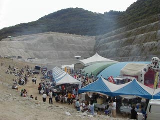
However, to my great disappointment, one of the events was an "Exploration Tour of the bottom of the lake of the Kosatogawa Dam," where you can see the inside of the embankment and the dam up close from the bottom of the lake. I thought I had to take part, but the application deadline had passed a few weeks before the event, and my ambition was dashed.... I am so disappointed.... I'd like to visit the event........ I don't see anything about such a tour on the dam's website.
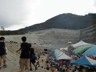
Aha, this is where I sink. My heart is already sinking.
Moreover, the weather turned bad and we had to leave because we did not have rain gear.
dam characteristics
| da mu | form (something takes) | gravity-fed concrete dam |
|---|---|---|
| Bank height | 114m | |
| Bank length | 331.3m | |
| Dam volume | 750,000m3 | |
| Elevation of non-overflow area | E.L. 404.0m | |
| savings water (esp. cool, fresh water, e.g. drinking water) pond | catchment area | 55km2 |
| Reservoir area | 0.55km2 | |
| Total storage capacity | 15,100,000m3 | |
| Effective water storage capacity | 12,900,000m3 | |
| Year of launch | 1979 | |
| Year Completed | 2003 | |
Other facilities/observations
| Parking lot | ○ | ...I regret that I should have taken more pictures. Especially the inside of the administration building and the Kori Castle Bridge. Isn't this an important point? If I get a chance to go back, I will take pictures. Hi. I think the facilities are good even ◎ in all respects. |
|---|---|---|
| Toilet | ○ | |
| Park | ○ | |
| PR Exhibition Hall | ○ |
Comment