

Location: Yunishigawa, Nikko-shi, Tochigi
Date of interview: Saturday, October 02, 2010
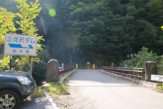
Approach "Mikawasawa Bridge" from Yunishikawa Onsen on Tochigi Prefectural Route 249
After the Yunishigawa Dam construction site tour (2010/10/02), "Kawaji Dam Catwalk Experience & Amphibious Bus" or "Mikawasawa Dam and Afterdam tourAfter much hesitation, we decided to continue our tour of the dam. Well, we will probably be able to ride the amphibious bus again, and we can also visit the catwalks by formally applying for a tour.
This is why the Mikawasawa Dam.
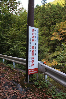
After driving westward from Yunishigawa, you will see this sign and a bridge. However, since it is quite a distance and the car navigation system was not very good, I gradually became concerned....
Gate blocking the road to Mikawasawa Dam
It is a feature of this Mikawasawa Dam that it is not clear whether it is off-limits to both people and vehicles, or only to vehicles. However, it seemed that people who had visited the dam in the past had done so on foot, so we decided to park our car at the location shown in the first photo and walk to the dam. This was the location that I had heard about from MARC, though. *Parking is at your own risk. (Note added on 2022.7.9: According to the prefectural website, the forest road to the management office is now off-limits.)
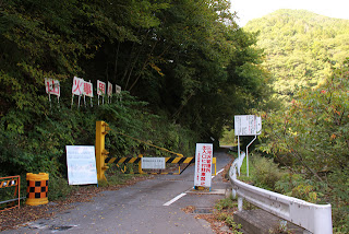
According to marc, it is not always available, as anglers sometimes park there.
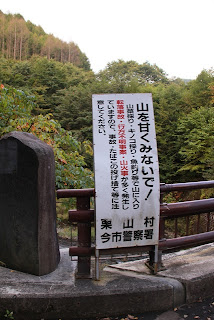
Don't underestimate the mountain!"
I was alone, so these signs made me feel discouraged....
Besides, it would be a shame to get lost in a dum-dum situation.
However, dam tours are at your own risk.
Still, I didn't bring a bear bell or anything...at that point, you could say I was underestimating.
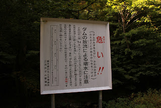
DANGER!!!!" ...Signs warning of discharge
According to my calculations, it was only a 30-minute walk, but Mr. Marc said it might take longer. I was not sure how long it would take to get there, but I was not sure. I was worried because I was unfamiliar with the area, and I could not get a signal from Softbank from the Gojuri Dam (0559-Ikari Dam).
Signs reading "Many missing persons and slip-and-fall accidents."
These signs that scare me along the way.
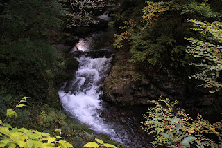
Migawasawa River
Scared of anxiety, I tried to take some pictures of the river... and then I heard a noise behind me!
interpoint (interword separation)
interpoint (interword separation)
interpoint (interword separation)
It was Mr. MARC.
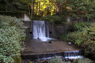
Erosion control weir on the way
At Yunishigawa Roadside Station, I thought marc had already left before me, but it seemed he had passed me somewhere along the way. Marc was on a bicycle, but he had brought a bell and a radio to protect himself from bears, which revealed my ineptitude.... But it was really reassuring.
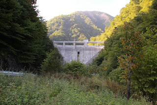
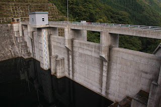
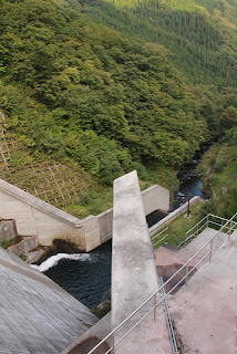
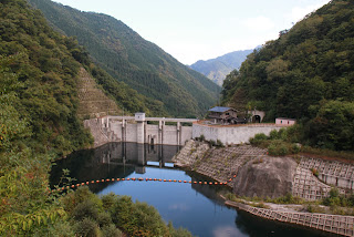
View of the levee from downstream
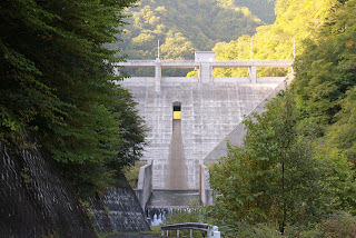
After 30 minutes of walking from the roadblock, the embankment finally came into view! Finally, the embankment came into view!
View of the levee and reduction works from downstream
I thought, "Oh, I can see it from directly below," but unfortunately, the road leading directly below was off-limits.
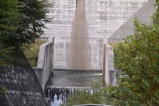
View of the force-reducing structure from downstream
Sorry, I'm not used to the new camera and it's at an angle.
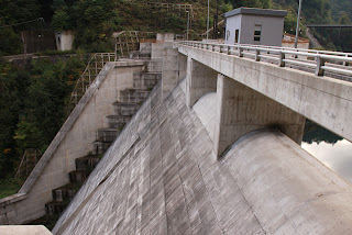
View of the crest gate from downstream
Sorry, this picture is also skewed. The crest is a natural overflow type, which is in vogue. You can see the other side.
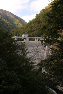
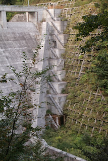
View of the levee from the downstream side of the right bank
We walked up a slope that became steeper and steeper. Marc is pushing his bicycle, but it looks painful too....
We are getting a little bit closer to the embankment, but we can only catch glimpses of it between the trees....
View of footing and conduit wall from the downstream side of the right bank
I wanted to go down that footing, but for once I was rather praying that it was fenced off.
Mikawasawa Dam Area Guide Map
The presence of such a guide map suggests that this road is not accessible by car, but walking would be OK. Unless it is for climbers, hikers, fishermen, etc. to see, this kind of thing would be useless. (Note added on 2022.7.9: According to the prefectural website, the forest road to the management office is now off-limits.)
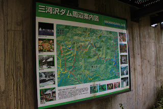
Also nearby was a large sign with detailed information about the Mikawasawa Dam. According to the sign, the Mikawasawa Dam functions for flood control, river maintenance, and water supply, but the demand for water has increased due to the increase in the number of tourists in Kuriyama Village downstream.
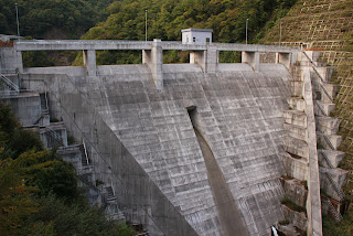
View of the levee from the observatory on the downstream side of the right bank
Oh, at last we can see the whole picture. There is also an observation deck from which one can fully enjoy the view of the Mikawasawa Dam. The Mikawasawa Dam was completed in 2003, so the concrete surface is beautiful.
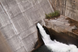
View of the irrigation discharge from the observatory on the downstream side of the right bank
A water diversion and discharge facility is located at the bottom of the embankment on the left bank side.
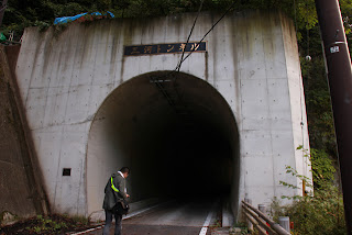
Mikawa Tunnel
Next, head for the top of the mountain. To get to the top of the mountain, go through this tunnel. By the way, although it is called "Mikawa," this is not Aichi Prefecture.
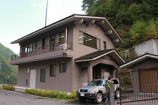
Mikawasawa Dam Management Station
I will offer a visit to the management office just to be sure. It would be a shame to enter the top without permission and get angry. However, it was Mr. marc who took the initiative.
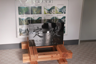
cornerstone
The cornerstone sits near the entrance to the administration. Me and marc taking a picture of it. The management office staff was wondering why we were there.
View of the embankment on the lake side from the right bank
The water level is quite low. It has not reached the orifice either, but from the wetness of the bank, it may have been discharging through the orifice until a few hours ago.
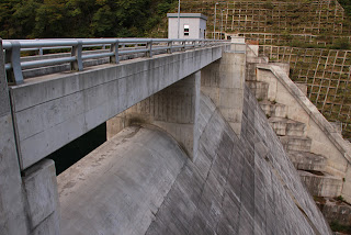
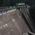
View of the top edge from the right bank
The high railings at the dam site are wood-grained. Is this in consideration of the landscape?

View of the conduit wall from the right bank
The ledge wall sticking straight out was somehow impressive.
View of the levee downstream from the right bank
I would like to see it overflowing from here. Well, it is not limited to the Mikawasawa Dam.
View of the flow-conducting section and force-reducing structure from the top edge
A triangular spoiler is attached to the top of the orifice.
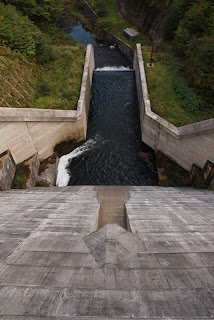
View downstream from the top
You can see a path just below the right bank side, but unfortunately that path is off-limits.
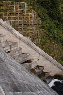
View of the footing on the right bank from the top edge
The footings and conduit wall are both magnificent. You can see the observation deck in the upper left corner.
View of footing on left bank from top edge
As is the case on both banks, I wonder if there is some intention behind the fact that the footings have different dimensions for the "kick" and "tread" as in stairs.
View of the levee downstream from the left bank
As I have said many times, I would love to see the overflow from here. But even though I know it will overflow, I am sorry to say that it is too far away for me to get there right away.
View of the embankment on the lake side from the left bank
Come to think of it, the water diversion discharge seems to be a selective intake, but I have not confirmed this.
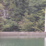
View of the dam lake
Whether it is because it is approaching evening or because of the original, the dam lake is darker in color. The mountains are also turning much more color.
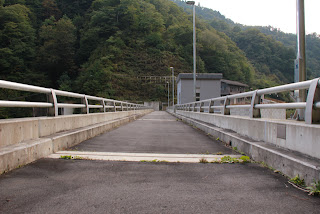
Still, I can only assume that the bridge was built for someone to see. It is a bit unfortunate that the bridge is closed to public vehicles, but I guess that's for environmental and safety reasons.
View of the top edge from the left bank
In this way, it is an ordinary embankment, but it is good to visit it in a hiking mood. While having a lunch box.
And we will continue further upstream after this.
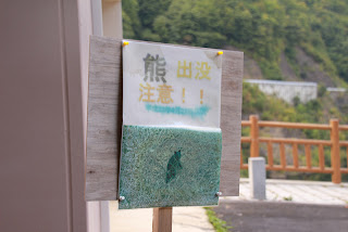
Beware of Bears! Sighting on April 21, 2010
It seems that bears have appeared in the vicinity. Especially in 2010, there was a series of bear attacks, so when I see signs like this, I feel more and more ashamed of myself for not having equipped myself with anti-bear gear....
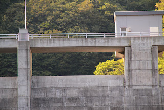
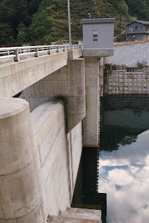
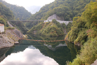
Setogongen Bridge
The bridge over the dam lake is named "Seto-Gongen Bridge. Again, the bridge is named "Seto," a place associated with Aichi Prefecture. Is there any relationship between "Mikawa" and "Seto"? Incidentally, "Gongen" seems to have been named after a waterfall called "Gongen Falls" upstream.
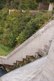
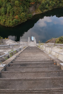
Incline?
It looks like an incline, but we'll go there later. Still, it is long and steep.
Steep stairs disguised as an incline
A boat is moored in the dam lake, but it does not seem to serve as an incline. So, it was just a staircase. However, the stairs are so steep that you might fall down.
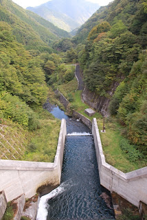
View of the embankment from the Seto-Gongen Bridge upstream
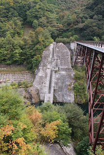
I think the best view point of this dam is from here. The embankment is normally called the front side of the dam, but this is the best place to see the front side of the embankment. In addition, the surrounding mountains and the scale of the dam make you lose a sense of scale, and the dam looks like a miniature.
We then headed back down the mountain road where we might see bears.
dam characteristics
| River Name | Tone River System Mikawasawa River |
| Objective | Flood control, agricultural disaster prevention, unspecified water, river maintenance water, water supply water |
| Model | gravity-fed concrete dam |
| Bank height | 48.5m |
| Bank length | 97.5m |
| Dam volume | 58,000m3 |
| Watershed Area | 13.9 km2 |
| Reservoir area | 7ha |
| Total storage capacity | 899,000m3 |
| Effective water storage capacity | 829,000m3 |
| Dam operator | Tochigi prefecture (Kantou area) |
| Main body constructor | Kajima Corporation, Sumitomo Mitsui Construction Co. |
| Year of launch | 1984 |
| Year Completed | 2003 |
Other facilities/observations
General traffic is prohibited from the entrance of the road to the dam on the prefectural road. You will have to park your car near the entrance, but that does not mean there is a parking lot.
| Parking lot | × |
| Toilet | ○ |
| Park | × |
| PR Exhibition Hall | × |
| Fishing | ○ |
Comment
Good evening!
Thank you very much for your help on that occasion.
I feel like I've missed something already. w
I see you will be attending the 11/22 event as well.
Thank you again.
It goes by so fast!
Even though it was last month w
So we can be together again on the 22nd!
Please be gentle with us, too. w