
Location: Aza Kaiji, Nanto City, Toyama Prefecture, Japan
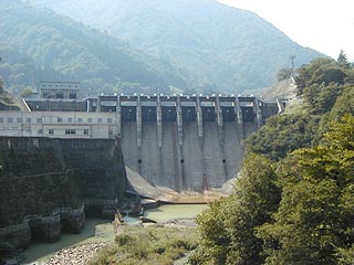
View of the levee from the bridge on the downstream side

The Obara Dam is located eastward on Route 156 from the Gokayama IC of the Tokai-Hokuriku Expressway, but it is easy to miss because there is a tunnel near the embankment. This dam is designed to generate electricity, and there is a power generation facility right next to the embankment. There are few spots to take pictures, and as a result, this is the only picture I was able to take.
dam characteristics
| da mu | form (something takes) | gravity-fed concrete dam |
|---|---|---|
| Bank height | 52m | |
| Bank length | 158.2m | |
| Dam volume | 93,000m3 | |
| savings water (esp. cool, fresh water, e.g. drinking water) pond | Watershed Area | 814.5 km2 |
| Reservoir area | 56 ha | |
| Total storage capacity | 11,741,000m3 | |
| Effective water storage capacity | 5,099,000m3 | |
| River Name | Shogawa River System Shogawa River | |
| Year of launch | 1939. | |
| Year Completed | 1942 | |
Other facilities/observations
| Parking lot | × | The reason it is called "PR Exhibition Hall" is because there is an electric power museum of Kanden nearby. Unfortunately, due to lack of time, we had to abandon our coverage there.... |
|---|---|---|
| Toilet | × | |
| Park | × | |
| PR Exhibition Hall | ○ |

Comment