
Date of interview: Saturday, August 03, 2013
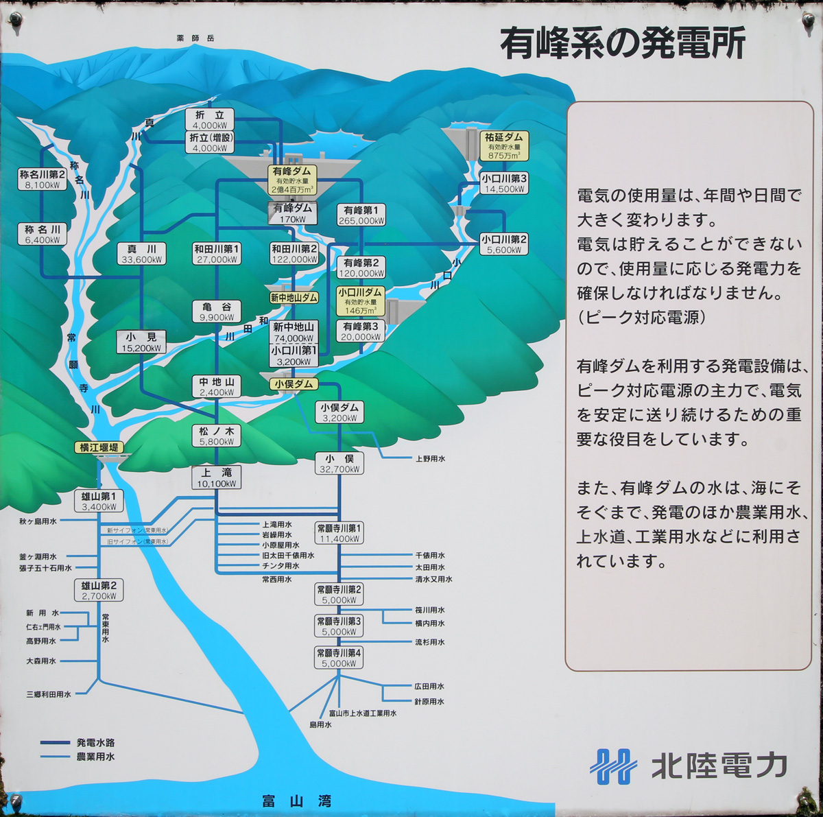
We came to Oguchigawa Dam from Arimine Dam via Sukenobu Dam. Like the Arimine and Sukenobu dams, the Oguchigawa Dam is also a Hokuriku Electric Power Company dam, and water is pumped into the Arimine No. 3 Power Plant (underground) located directly below it, generating up to 20,000 kW of electricity.
The place names, dam names, and power plant names are all jumbled together, so it would be easier to understand if you look at the diagram. (I'm confused myself as I explain it.)
View of the upstream face of the embankment from upstream on the right bank
Since the Arimine Dam is downstream from the Arimine Forest Road Oguchigawa Line, the upstream face of the embankment comes into view after a short winding drive.
Arimine No.2 Power Plant of Hokuriku Electric Power Co.
Looking backward from the location in the photo above, you can see the Arimine No. 2 Power Plant. Water is supplied from the left bank intake of the Arimine Dam to this location along the Wada River via the Arimine No. 1 Power Station located upstream of the Shin-Nakachiyama Dam.
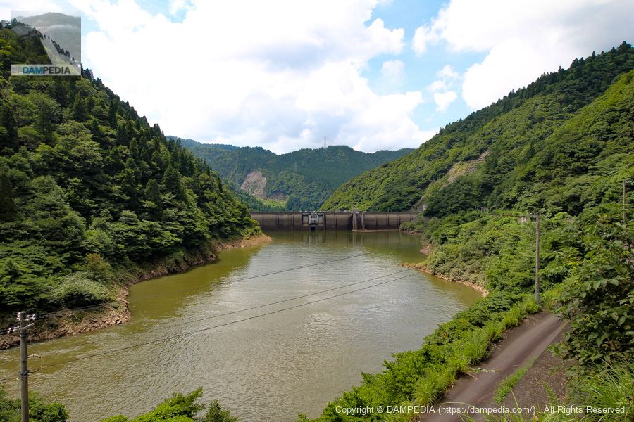
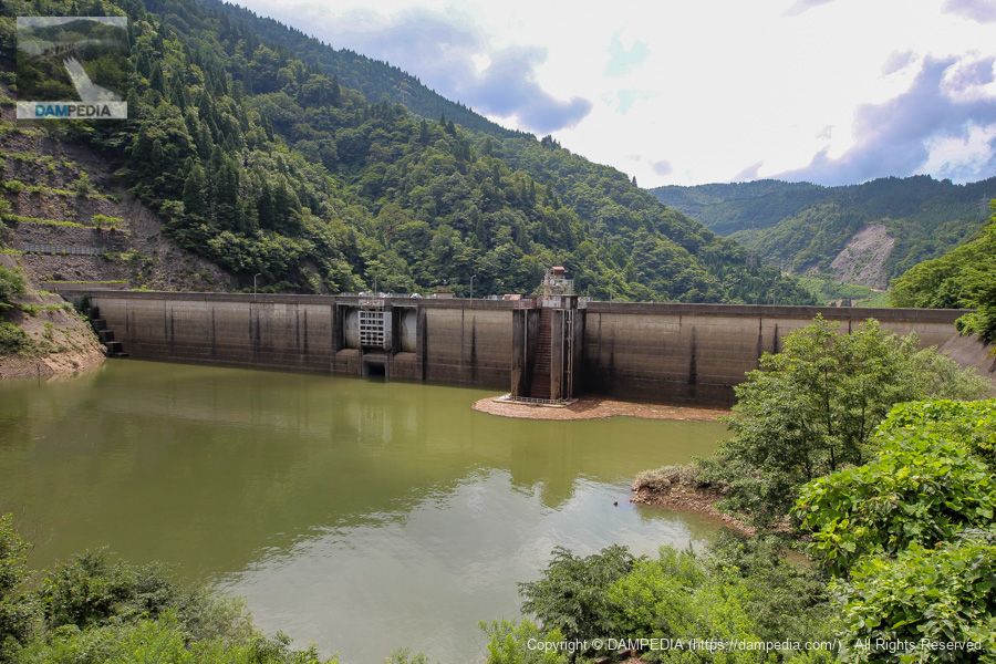
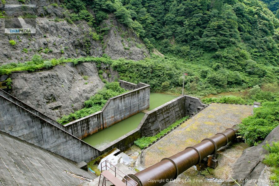
Looking upstream from the right bank
It has been moved further to the levee side. The crest has two radial gates. In between them, there is a conduit gate for a high pressure radial gate. It is unusual for a dam dedicated to power generation to have a conduit gate. There is also a water intake for power generation near the right bank.
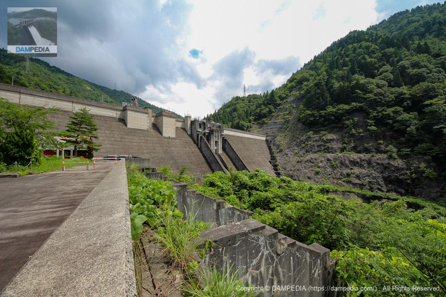
Looking downstream from the right bank
We moved to the downstream side. The top end of the dam is off-limits, but apparently there was a branch in the forest road tunnel that led to the top end, and it was possible to enter the dam site on the right bank.
The Oguchi River Dam seen from the downstream side has a strange embankment that at first glance does not look like a dam dedicated to power generation. If anything, it looks more like a prefectural dam built at the end of the Showa period. By the way, there is a concrete structure in the foreground of the photo, which may be the remains of a plant at the time of construction.
Johnson valve
On the right bank, a Johnson valve originally used at the Oguchi River No. 3 Power Plant is on display.
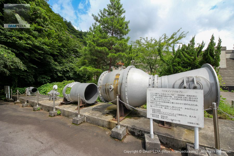
The valve on display here (made in England) was installed on top of a hydraulic iron pipe when the Oguchigawa No. 3 Power Station was built in 1931, and has been working for about half a century as a valve for water supply and shutoff.
Local Signboard
It was replaced due to obsolescence in conjunction with a complete renovation in May 1989.
It has served its purpose for many years and is displayed here for everyone to see.
1. Origin of the name
It was invented by the English engineer Johnson and named after him.
2. Year of production: 1930
Production Company Brakeborough, UK
Oguchigawa Shrine
On the other side of the Johnson Valve is the Oguchi River Shrine. It is not known if it was there before construction or if it was enshrined with the construction.

Looking downstream from just below the right bank
Oguchigawa Dam was completed in 1981, making it one of the younger Hokuriku Electric Power Company dams in the vicinity. It is such a dam that is watched over by great seniors.
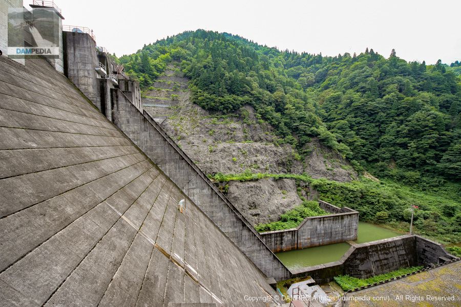
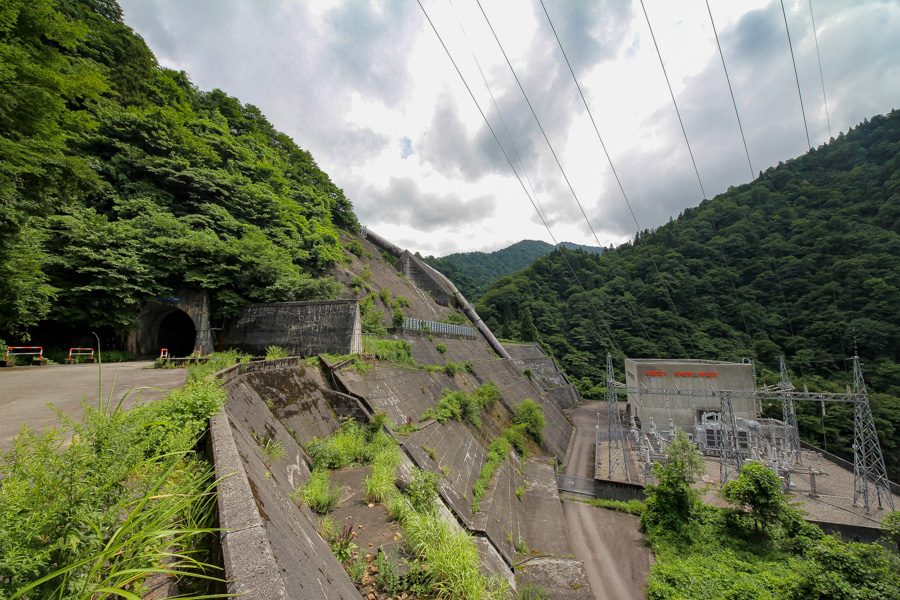
View of the downstream face of the embankment from just below the downstream side
The leftmost one is the water intake, but is the one just to the right of it also an intake? It is interesting that there is an air vent hole attached to it.

Looking downstream from just below the right bank
A part of the hydraulic pipe extending from the water intake is exposed and leads directly to the underground power plant. The color of the hydraulic pipe is somewhat nice.
You can visit the dam except for the top end, so I would definitely stop the car on the way to (or on the way back from) Arimine Dam and take a good look at it. This is the Oguchigawa Dam.
Oguchi River Dam Specifications
| Location | Mizusu, Toyama City, Toyama Prefecture |
| River Name | Joganji River system Oguchi River |
| Objective | P(Power generation) |
| Model | G(gravity-fed concrete dam) |
| Bank height | 72m |
| Bank length | 245m |
| Dam volume | 250,000 m3 |
| Watershed Area | 251.1 km2 (direct: 31.1 km2, indirect: 220 km2) |
| Reservoir area | 11 ha |
| Total storage capacity | 2,718,000 m3 |
| Effective water storage capacity | 1,469,000 m3 |
| Dam operator | Hokuriku Electric Power Co. |
| Main body constructor | Maeda Corporation, Magara Construction Co. |
| Year of launch | 1977 |
| Year Completed | 1981 |
| Name of Dam Lake | - |
Other facilities/observations
| Parking lot | △ |
| Toilet | × |
| Park | × |
| PR Exhibition Hall | × |
| Fishing | ? |


Comment