
Location: Mitsui, Tsukui-cho, Sagamihara-shi, Kanagawa
Official Web site:.沼本ダム(相模川河水統制事業) – 神奈川県ホームページ
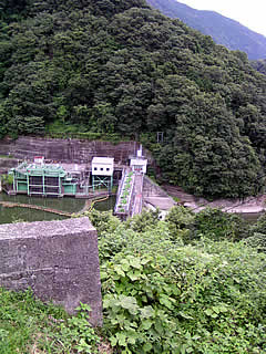
View of the embankment from the right bank
When the water level of Lake Tsukui, dammed by the Shiroyama Dam, rises, the embankment sinks. This is the Numamoto Dam.
It is almost invisible because it is covered with grass and trees, but I could see that it is actually submerged. The embankment is supposed to be 25.5 meters high, but it does not look that high at all. The top of the embankment is supposed to be 126 meters long, but it does not look that long. The length is probably due to the fact that the angle from here is hidden by grass and trees. The site of the Bureau of Water Utilization has a photo of the embankment taken from the front, which gives an idea of its length.

View of the embankment from the right bank
It was difficult to photograph because of the fence, so I used a stepladder for the first time here. The stepladder was purchased at a home improvement center in Higashirinma, Sagamihara City, on the way from Yokohama. It was immediately useful.
Still, it is sad to see so little of it.
The Numamoto Dam was built to maintain the flow of water used for power generation at the Sagami Power Station downstream as well as to use the water for water supply.

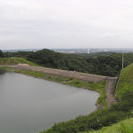
View of the embankment from the right bank
If you zoom in, you can vaguely see that the water is being released.
Rumor has it that as the water level drops, a route will appear that will end up directly downstream of the levee.
Normally, it can only be seen from this angle.

Stairs leading to the levee
It is supposed to be possible to reach the dike from here, but unfortunately, it is off-limits and a fence blocks the way.

Numamoto Dam Specifications
| Model | gravity-fed concrete dam |
| Objective | Water for irrigation/water supply/power generation |
| Bank height | 25.5m |
| Bank length | 126.0m |
| Dam volume | 52,000m3 |
| Watershed Area | 947.2 km2 |
| Reservoir area | 35 ha |
| Total storage capacity | 2,330,000m3 |
| Effective water storage capacity | 620,000m3 |
| River Name | Sagami River System Sagami River |
| Year of launch | – |
| Year Completed | 1944. |
| Access to D@M | Get off at the Sagamiko IC (or Sagamiko East Exit) on the Chuo Expressway, take Route 20 toward Hachioji (Sagamiko East Exit toward Yamanashi), turn right at the T intersection with Route 412 onto Route 412 (turn left from Sagamiko East Exit), and drive about 4.3 km toward Sagamihara City on the national highway with Sagami Dam on your left. Turn left at the intersection with a JOMO gas station on your left (if you see a 7-Eleven on your left or cross the Doshi Bridge, you have gone too far). Then go straight down the road and you will see a fence at the end of the road, where you can park on the street. You will see the dike behind the fence (the way directly below is unknown. It is probably only accessible on foot.) |
Other facilities/observations
It is located in a very hard-to-find place, but if you do your homework, you should have no problem finding it. I was also anxious to find it, but I managed to get there in one shot. It is a dam that deserves to be called a "phantom dam," both in terms of being submerged and in terms of being difficult to find.
| Parking lot | × |
| Toilet | × |
| Park | × |
| PR Exhibition Hall | × |
Accommodations that may be close to Numamoto Dam


Comment