
Location: Oaza Komono Aza Yakeo, Komono-cho, Mie-gun, Mie Prefecture
Date of interview: Tuesday, November 23, 2010
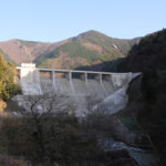
View of the levee from downstream
The Komono Regulating Pond is a dam located in the central part of the Mie Irrigation Canal managed by the Japan Water Agency. It is an important dam that supplies water to the cities and towns of Yokkaichi, Suzuka, and Komono, along with agricultural water to the Takeya Canal, while conducting water from the Nakasato Dam and storing water from the Tamitsu River, Mitaki River, Uchina River, and Mimai River and delivering it to the main canals downstream The dam is also used to supply water to the municipalities of Yokkaichi, Suzuka and Komono.

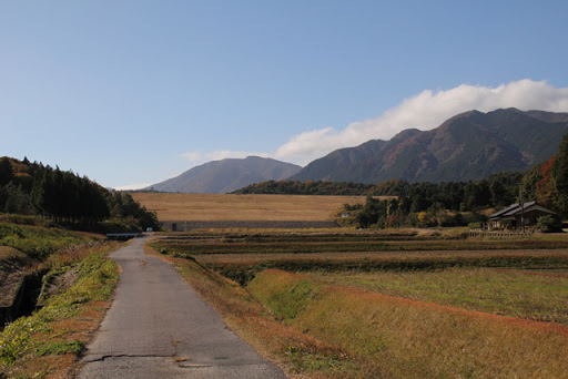
Downstream, the countryside spreads out, and some dams give a direct impression of being "the keystone of agriculture.
View of the levee from just downstream
The downstream side has a lock section like a rockfill dam.

View of the levee from just downstream
This is a beautiful shell section of the dike. The dam is well cared for in detail.

Pumping station to supply water to rice paddies?
We do not know if this facility is directly related to this dam, but water from this facility was supplying water to the rice fields spreading immediately downstream.

View of the levee downstream from the left bank
There is no fence on the downstream side of the top edge and it is very simple.

View of the top edge from the left bank
It is a very wide top. It is wide and long enough for a Cessna to take off and land.

View of the heliport on the left bank
Heliports are often found at dams of the Japan Water Agency. The Nakasato Dam also has one.

View of the embankment on the lake side from the left bank
The shell section on the downstream side was also beautifully maintained, but the tensioned stonework on the dam lake side is also very beautiful. Incidentally, the official website of the Japan Water Agency says that it is "rubble stone tension," but since it is neatly organized, it is not "rubble stone tension.stonemasonI assumed that it was a "one". Is the construction between each of these?

View of the dam lake from the left bank
Birds were resting their wings on the dam lake and businessmen were resting their bodies on the dam site (not skipping).

Signboard for Mie Water
A sign for Mie Water was installed. It reads, "Information Board of Gratitude."

View of the dam lake and embankment from the left bank
The left bank (or is it?) is slightly elevated, and beyond the embankment you can see the urban area of Komono Town and the industrial area of Yokkaichi in the distance.

Water flows from the main canal to the dam lake
This is the water injection works leading from the main channel of the Mie Irrigation Canal to the dam lake. From a distance, it looked like a cascade, but it seems to be a series of concrete blocks like a monolith to reduce the force. On this day, the water was flowing at a considerable flow rate and making a loud jabbering sound.

Water flows from the main canal to the dam lake
I would have liked to see a little more of this area, but unfortunately it is off-limits.

Independent Administrative Institution Japan Water Agency Mie Water Management Office
I went around the dam lake in a circle. This is not only the control center for the Komono Regulating Pond, but also the control center for the Mie Waterworks, which manages all of the Mie Waterworks.

Toilet facilities
Restrooms are provided, but are only available from 9:00 am to 5:00 pm on holidays.

View of the Suzuka Mountains from the top
It is quite a nice season and the weather is good, so you can clearly see the Suzuka Mountains. It is quite a magnificent view. Whenever I come to this neighborhood, I think that I might like to live in Komono-cho when I start living on a pension. There are stores along the national highway, a hospital, and the Yunoyama hot spring. And after all, there is a dam.

View of the embankment on the lake side from the right bank
This is really beautiful taut stonework. The stone looks black in the area slightly above the lake surface, perhaps because that is where the water level usually is.

View of the right bank from the top
It appears to be surrounded by a square mesh field, but it is a bottom intake due to the shallow depth of the water and the water intake facilities at the bottom of the dam lake. The water taken in here is carried to the Kasato Regulating Pond via the trunk canal and distributed to farmland in Komono Town and Yokkaichi via the Takeya Irrigation Canal. Water is also delivered to the Mizusawa Water Filtration Plant of the Mie Prefectural Government just below the embankment on the right bank.

On the right bank, there are stone monuments, etc.
The area around the monument is also beautifully maintained. The only thing that bothered me was that most of the stone monuments are placed in a position where they can be seen from the dam lake, but for some reason, this dam is facing the opposite direction.

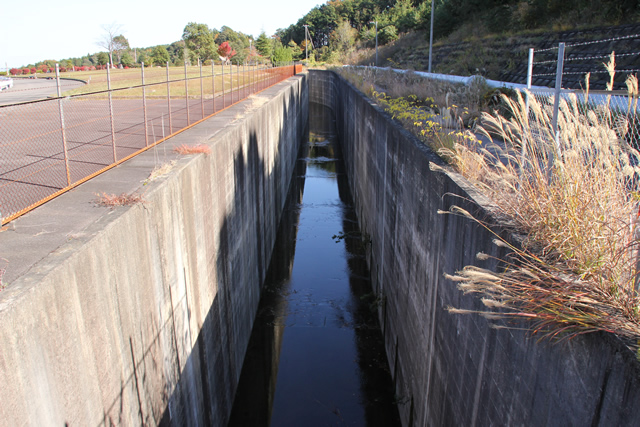
View of the conduit
This is a long conduit of the type often seen in earth dams of the Japan Water Agency.
View of flood discharge
This is another type of free overflow flood discharge often seen in relatively large earth dams and rockfill dams.

View of the water main and the Mizusawa Water Filtration Plant of the Mie Prefectural Public Enterprises Agency from the top
The building in the back is the Mizusawa Water Filtration Plant of the Mie Prefectural Government, and in the foreground is the conduit from the flood discharge.

View of the flood discharge from the top
The structure in the back.Flood dischargeThe area in front of the screen is the bottom intake.

View of the top edge from the right bank
The contrast between the wide top edge and the mountains is interesting.

View of the levee downstream from the right bank
It's an impeccably maintained dam here and there. Not only that, it is simple.

View downstream from the top
I am sure that the fresh green season is also a wonderful and beautiful green world. I would definitely like to visit the dam in early summer.

Komono Regulating Pond Specifications
| River Name | Mitaki River System Aka River |
| Objective | Irrigation water, water supply water, industrial water |
| Model | earth dam |
| Bank height | 28.4m |
| Bank length | 674m |
| Dam volume | 990,000m3 |
| Watershed Area | 0.8km2 |
| Reservoir area | 25 ha |
| Total storage capacity | 1,650,000m3 |
| Effective water storage capacity | 1,600,000m3 |
| Dam operator | Public corporation for water resources development, 2 works |
| Main body constructor | Taisei Corporation |
| Year of launch | 1986 |
| Year Completed | 1989 |
| Name of Dam Lake | Lake Kirara |
Other facilities/observations
There are also parking lots by the control center and at the dam site on the left bank. As I mentioned in the article, the restrooms are open on certain days of the week. It is a little difficult to judge whether the park is a park or not. Fishing is totally prohibited. Please do not fish.
| Parking lot | ○ |
| Toilet | △ |
| Park | △ |
| PR Exhibition Hall | × |
| Fishing | × |
Accommodations that may be close to Komono Regulating Pond

Comment