
Location: Higashiomi City, Shiga Prefecture
Official Web site:.Eigenji Dam Management Office
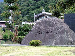
stone monument
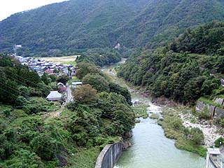
Eigenji-cho, where Eigenji Dam is located, is home to Eigenji Temple, which gave the dam its name, and is also famous for its autumn foliage. On the day of our visit, it was still too early to call it autumn, and the leaves were just beginning to change color.
Eigenji Dam is also located along the Happu Highway R421. There is a theory that the name "Happu Kaido" comes from the eight winds that were created by Isetsuhiko-no-mikoto, and from the eight peaks of the small mountains in the vicinity...in other words, eight peaks.

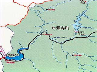
Map marked on a sign at the left bank dam site
The Happu Highway narrows as it goes upstream from the Eigenji Dam, and there is "Ishigure Pass," which is famous among enthusiasts of that area as a "bad road. The Eigenji Dam and the second Eigenji Dam are scheduled to be constructed upstream of the Eigenji Dam, and as a matter of course, there is an ongoing battle over the pros and cons of the construction of the dam. The photo on the left is a location map of the Eigenji Dam and the second dam. After this interview, we went to Ishigure-Toge, but unfortunately we could not find out more about the planned site of the second dam.
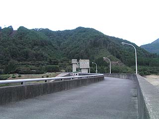
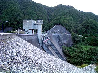
View of the top edge from the left bank
The embankment is not straight, but rather is bent in the middle. The tower seen over there is an intake tower. It is rare to see an intake tower located in the center of the dike.
Incidentally, the top end is closed to automobile traffic. There are only a few parking spaces on the left bank, but there is a fairly large parking lot on the right bank. However, to park there, you will have to go quite a long way around.
View of the levee from the downstream side of the left bank
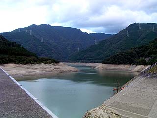
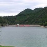
View of the dam lake from the left bank
The water in the dam lake was relatively low at this time.
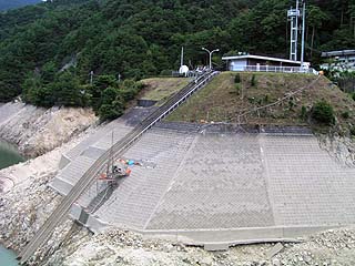
View of the control center and the incline from near the top of the left bank
The reason for the low water level in the dam lake seems to be related to the construction work near the control center. An incline has been installed here.
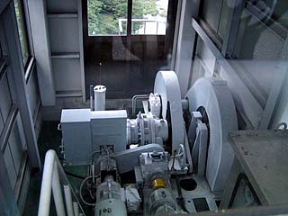
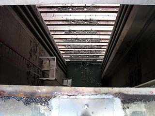
Inside the gate operation room
When you come to the center of the top end, there is a gate operation room with a glass window so that you can look inside. It is a rather large machine.
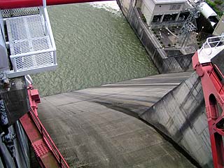
View of the conduit from the top edge
The view from the gate is quite high. The power generation facility can be seen in the upper right.
Looking downstream from the top
Eigenji Temple is located just ahead, and is quite an old and scenic place.
View of the lower part of the intake tower from the top
I took this photo looking down the camera through a gap in the fence of the intake tower. Thinking back, this is probably the first time I've ever looked under the intake tower. The fence makes it impossible to actually see it, but it is scary nonetheless.
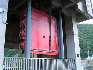
View of the multi-level gate of the water intake tower
I don't think I had ever seen the gate of the intake tower so close up. You can really feel how big it is.
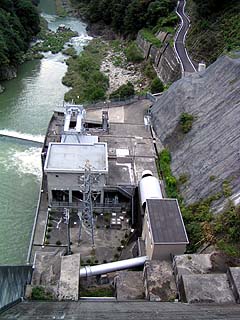
View of the power generation facility from the top
The power generation facility was roaring as water was being discharged from the hollow jet valves.
View from the top of the dam Ruins of a house (?) at the bottom of the dam from the top
Since the water in the dam lake was relatively low, the remains of foundations that may have been housing can be seen. With the construction of the dam, 175 households were submerged, and 213 households were relocated.
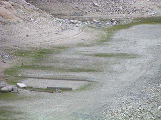
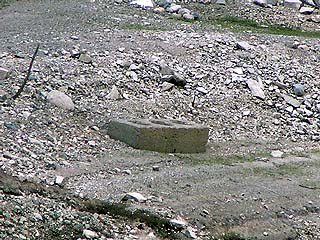
View of the remains from the top
We do not know if this concrete is the remains of the foundation or not, but it seems to tell us the history of the dam construction.
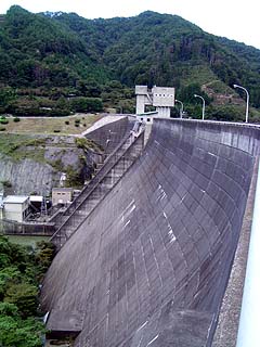
View of the fill and concrete section of the embankment from the downstream side of the right bank
Walking in from the left bank, it appears to be a gravity concrete dam, but there is a small fill section on the right bank, making it a composite dam.
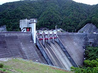
View of the levee from the downstream side of the right bank
The crest section has four radial gates. When the fill section is taken out of the viewfinder, it looks like gravity concrete.
dam characteristics
| Model | Gravity Concrete Fillcombined dam |
| Objective | Irrigation water, power generation |
| Bank height | 73.5m |
| Bank length | 392.0m (Gravity section: 272.0 m, Fill section: 120.0 m) |
| Dam volume | 407,600m3 (Concrete 384,300 m)3Embankment 23,300m3) |
| Watershed Area | 131.5 km2 |
| Reservoir area | 98 ha |
| Total storage capacity | 22,741,000m3 |
| Effective water storage capacity | 21,984,000m3 |
| Surface Intake Facilities | Multistage gate: 1 gate with 3 tiers Width 5.0m x Height 27.0m |
| Low Water Intake Facility | 1 gate for low water intake Width 2.0m x Height 2.5m |
| water discharge facility | Hollow jet valve phi1,200mm 1 unit |
| Maximum Water Withdrawal Volume | 15.4m3/s |
| Gate type and number of gates | Radial gate 4 gates |
| Dimensions | 2 gates on the left bank side 9.375m wide x 8.103m high 2 gates on the right bank side 9.375m wide x 9.060m high |
| overflow height | 2 gates on left bank side E.L.262.70m 2 gates on the right bank side E.L.261.70m |
| design flood volume | Gravity section 1,530m3/s Phil Department 1,840m3/s |
| River Name | Yodo River System Aichi River |
| Year of launch | – |
| Year Completed | 1972 |
| Access | Get off at Meishin Expressway Yokaichi IC and turn right Go east on Route 421 (Happu Road) The rest is straight down the road. |
Other facilities/observations
It is the second largest existing dam in Shiga Prefecture, following the Anegawa Dam. Still, many of the dams in Shiga Prefecture are designed for irrigation purposes. Although Lake Biwa is located in the prefecture, there used to be a lot of problems due to lack of water, but what do you think?
| Parking lot | ○ |
| Toilet | × |
| Park | ○ |
| PR Exhibition Hall | × |
Comment
[Auto-post] Dam-Pedia Archives - Please take a look at it at your leisure - 1361 - Eigenji Dam http://t.co/hXUaCEcqd0