

National Highway 19. Dam over the Kiso River.
Location: Nagiso-machi, Kiso-gun, Nagano Prefecture, Japan
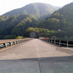
View of the levee from the bridge downstream
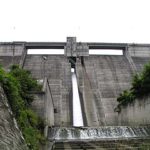
Yamaguchi Dam is located along Route 19. I wanted to stop by the embankment and photograph it from the side, but there was so much traffic and so many cars speeding that it was ridiculed as if it were a highway, so I photographed it from the bridge across from the embankment.
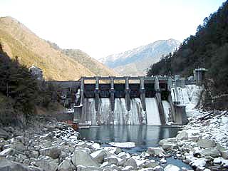
I took this photo on my way back from snowboarding in the Ontake area. Therefore, it was taken near evening and it was a little dark....
dam characteristics
| Model | gravity-fed concrete dam |
| Objective | generation (e.g. power) |
| Bank height | 38.6m |
| Bank length | 181.4m |
| Dam volume | 61000m3 |
| Watershed Area | 1534.5 km2 |
| Reservoir area | 31 ha |
| Total storage capacity | 3484m3 |
| Effective water storage capacity | 1264m3 |
| River Name | Kiso River System Kiso River |
| Year of launch | 1955 |
| Year Completed | 1957 |
Other facilities/observations
The opposite side of National Road No. 19 is an old road, but it is completely closed to traffic and inaccessible by car. This time, I photographed at the bridge located just after turning onto Prefectural Route 6 (Nakatsugawa-Yamaguchi line) at the traffic light east of the Zizumo Bridge, then turned right and passed under the national road. This bridge was also impassable, so I parked before the bridge and walked to the bridge. Anyway, it was a dam that was difficult to photograph.
| Parking lot | × |
| Toilet | × |
| Park | × |
| PR Exhibition Hall | × |
Comment