
Location: 1131-2, Aza Oaza Tashiro, Aoi-ku, Shizuoka City, Shizuoka Prefecture
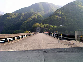
View of the top edge from the left bank

When we reached the Hatanagi No. 1 Dam, the twilight had faded away and we were finally at the end of our tour of dams on the Oigawa River system. The dam tour of the Oigawa River system finally comes to an end. The dusk-colored embankment makes me imagine the world of Hades. I wonder if I will visit a dam even in the afterlife. Secretly, when I die, I would like part of my remains to be sown in the dam lake of the dam with the highest embankment at that time (Kurobe Dam, after all?). (I guess it would be the Kurobe Dam?). In a manner of speaking, this is my last will and testament. I am not going to die right now, though.
View of the levee (downstream side) from the left bank
Incidentally, the top edge is open to automobile traffic. The rear of the photo above is the trailhead to the Southern Alps, including Mt. Therefore, cars are allowed only up to this point. In fact, if you go further upstream from here, you will find Akaishi Dam, but unfortunately, you will have to turn back because you do not know how to climb a mountain. However, there is a bus that takes you to a place near the lodge (apparently, only guests can take the bus...). There is also a memorial to those who died while climbing the mountain, and a card for climbers to fill out and a table to fill out the card. I saw these for the first time during my visit to the dam. In the photo on the left, you can see what appears to be the remains of something in the center of the river.
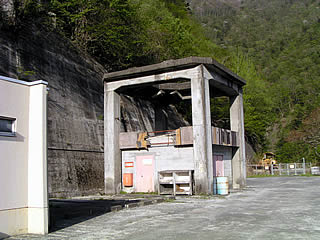
Gate operation room
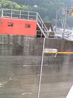
The gate operation room is small compared to the embankment. The embankment is a hollow gravity dam, which again is not what it appears to be.
Radial gate No.1
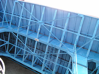
It is a radial gate with a really pleasantly beautiful light blue crested section. There are four radial gates.
Gate operation room, control center, remains...
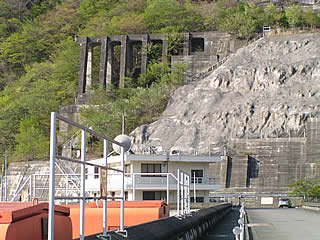
From the very front are part of the gate operation room, the dam control center, and the remains from the dam construction. Beyond the control center is the cenotaph. It was really windy at this point!
View of the flow-conducting wall from the center of the top edge
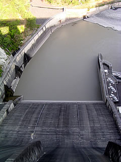
This is a relatively simple flow-conducting wall. The flow reducer is also simple.
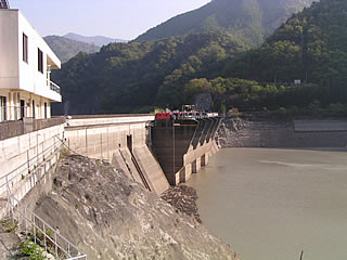
View downstream from the top
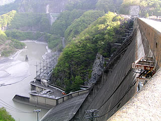
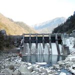
The Oigawa River is no longer there. Safety is maintained by dams. However, isn't the water discharge a little low for that purpose? However, the main purpose of this dam is to generate electricity. It is not for flood control. Incidentally, the 125-meter-high embankment is one of the world's largest hollow gravity dams, and the largest in Japan.
View of the embankment (lake side) from the left bank
The relatively low water level appears to have been the flood stage limit, as it was shortly before the flood stage.
View of the levee (downstream side) from the left bank
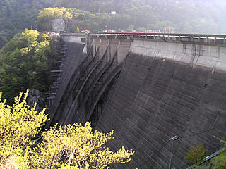
There are round holes in the embankment at equal intervals, which are probably windows for lighting the inside of the embankment.
Mysterious Remains
On the left bank, there are remains of an unknown purpose for which it was built.... It appears to be quite dilapidated. There is a large hole in the ceiling. It looks like a storage building using the remains of a crane foundation.
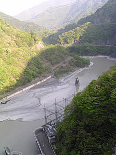
View of the dam lake from the top
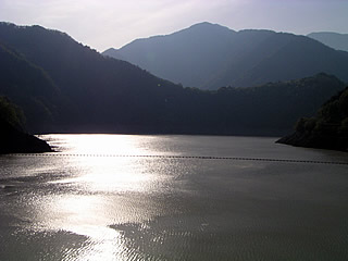
The mountains of the Southern Alps surround the dammed lake. The twilight-colored surface of the lake is quietly swaying. There are several dams in the Oigawa River system that I was not able to see, but when I see the mystical scenery, my frustration is blown away. With these thoughts in mind, I left the Oigawa River system behind.
dam characteristics
| da mu | Model | Hollow Gravity Concrete Dam | Access to D@M | Get off at Sagara Makinohara IC of Tomei Expressway The rest of the way is National Route 473 heading north toward Kawane Town. After entering Kawane Town and eating taiyaki at Ieyama, head north again on Route 473. After driving for a while, you will hit a T intersection with Route 362. Turn right at the intersection and go north on Route 362. There is a road that enters Prefectural Route 77 near Chigashira, so turn onto that road and continue north. When you pass the Okuizumi station in the Igawa line in the railroad, you will see the fork of the Sunmatakyo and the Precipice. Turn right onto Prefectural Route 388 toward the precipice. From here on, we will rely on our intuition (not much) and head for the Igawa Dam. After passing the Ousumi Dam and driving for a while, you will come to an intersection with Prefectural Road No. 60. Turn left on it (turn right is the Igawa Dam) The rest of the way is winding Prefectural Route 60. If you look at Akaishi Onsen on your right hand side and go through a tunnel, you will find Hatanagi second dam behind you on your right. (If you're not careful, you'll probably go too far.) Further upstream, you will arrive at the Hatanagi First Dam. Please note that the road around the dam is in danger of collapsing. |
|---|---|---|---|---|
| Objective | generation (e.g. power) | |||
| Bank height | 125m | |||
| Bank length | 292m | |||
| Dam volume | 598,000m3 | |||
| savings water (esp. cool, fresh water, e.g. drinking water) pond | Watershed Area | 318 km2 | ||
| Reservoir area | 251 ha | |||
| Total storage capacity | 107,400,000m3 | |||
| Effective water storage capacity | 80,000,000m3 | |||
| Name of Dam Lake | Hatanagi Lake | |||
| River Name | Oigawa River System Oigawa River | |||
| Year of launch | 1957 | |||
| Year Completed | 1962 | |||
| departing (from ...) (flash of) lightning | Power generation method | with Hatanagi No. 2 Dam dam pumping system | ||
| Volume of water used | Max. 160m3/s | |||
| effective dropout | Max. 101.7m | |||
| lifting height (of a pump, etc.) | Standard 82.4m | |||
| pumping up water (e.g. to a high place) | Standard 117m3/s | |||
| generating power | Up to 137,000 KW | |||
| water (esp. cool, fresh water, e.g. drinking water) car | Vertical-shaft Francis reversible pump turbine | |||
| Unit 1 | 51,800KW | |||
| Units 2 and 3 | 45,400KW | |||
| departing (from ...) (flash of) lightning machine | Vertical-shaft rotating field three-phase synchronous generator motor | |||
| Unit 1 | 58,800 KVA | |||
| Units 2 and 3 | 50,000KVA | |||
| Main Transformer | Three-phase oil-fed and air-cooled under load With tap switching device | |||
Other facilities/observations
| Parking lot | ○ | As you would expect, there are very few gas stations up here, so It is recommended to refuel in advance. |
|---|---|---|
| Toilet | ○? | |
| Park | × | |
| PR Exhibition Hall | × |
Comment