

Ironclad rockfill dam.
Location: Takaseiri, Oaza Taira, Omachi City, Nagano Prefecture
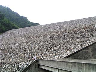
View of the levee from the downstream side of the left bank
Nanakura Dam is located further upstream from Omachi Dam. It is quite a large rock-fill dam, and you can get a sense of its size by looking up at it from directly below the embankment.
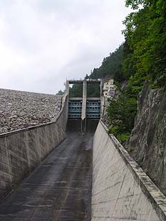
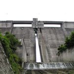
View of flood discharge
Two roller gates can be seen. To the right of them is the administration building. There are stairs on the left side of the spillway that lead up to the embankment, but due to time constraints and the weather, we decided not to go up. It is not possible to go up to the top by car.
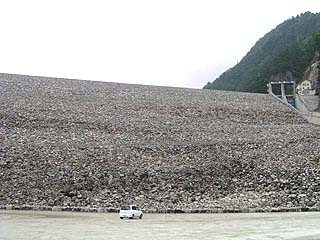
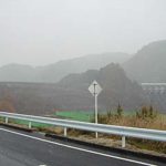
View of the levee from the downstream parking lot
A very large parking lot is located directly below the dike. Compare the size of the levee with that of a car.
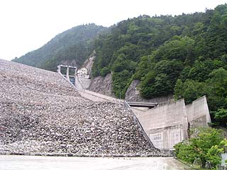
Entire water discharge channel
dam characteristics
| Model | rockfill dam |
| Objective | generation (e.g. power) |
| Bank height | 125m |
| Bank length | 340m |
| Dam volume | 7,380,000m3 |
| Watershed Area | 150km2 |
| Reservoir area | 72ha |
| Total storage capacity | 32,500,000m3 |
| Effective water storage capacity | 16,200,000m3 |
| River Name | Shinano River System Takase River |
| Year of launch | 1969. |
| Year Completed | 1978 |
Other facilities/observations
The Takase Dam is located further upstream, but the road to it is closed to private vehicles. The road between Nanakura Dam and Takase Dam can be reached on foot or by taking a local cab. Cabs cost 2,400 yen one way (as of 2021).However, since tours are regularly offered at the Takasegawa Tempco Museum and are free of charge, it would be quite advantageous to take a tour there. However, I did not make a reservation for the tour this time, so I did not cover the tour. We will see you next time.(The Takasegawa Tempco Museum was closed due to the Great East Japan Earthquake in 2011, and the bus tours were discontinued.)
| Parking lot | ○ |
| Toilet | ○ |
| Park | ○ |
| PR Exhibition Hall | × |
Comment
You can easily find the Nanakura Dam downstream on your left before the Nanakura Tunnel, but the road to the top of the dam has an entrance on the left in the middle of the tunnel (it took me two round trips before I realized it). co.jp/puchansdr/34162688.html
Thank you for your comments and information. I was aware that you fenced in the side holes. I simply didn't go to the top end. lol However, I haven't been there for a few years now, so I would like to go back soon. Including the Takase dam.
(polite term for) inviting another to one's home
Hello~♪♪♪
I just came here a few minutes ago about the Syrians,
Since it was an opportunity, I also had a chance to see the dam.
(Local) There was no mark on the Takase Dam,
Comment on Nanakura Dam.
Next time you go, please introduce Takase Dam with a photo...♪♪
https://blog.hashiyan.com/5098/
↑directional marker or indicator
My log (no one comes here, so I don't get known)
This is a very inconvenient place, though, as there is no cell phone reception here,
Autumn is very beautiful.
Beyond that point, there is a trail in the Northern Alps called Uraginza,
If you can afford it, you may even climb a mountain.
Incidentally, the Takase River is said to look green because of minerals mixed in the water, but I don't know what kind of minerals.
Now then... ♪♪♪
Hello!
Thank you for your comments on the Syrians.
I haven't actually been to Takase Dam yet.
It's hard to get up off my back when I know I have to walk that far.
I hope to visit this year! (and I feel like I say that every year)