
The dam is located at the foot of Mt.
Location: Mitake Wada, Kiso-cho, Kiso-gun, Nagano Prefecture
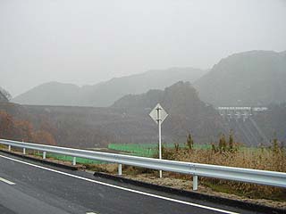
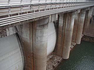
View of the levee from the downstream side of the right bank
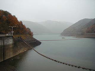
It is snowing because we covered the site in winter. As you can see, the conditions for shooting were terrible, and as you can see, it turned white. So, I was debating whether or not to release it to the public until the very end, but I am running out of stock, so I decided to go ahead and release it to the public.

To reach Makio Dam, enter Prefectural Road No. 20 from the Motobashi intersection on National Road No. 19, turn left at the Kurosawa intersection (some people do not put on blinkers because it looks like going straight...), and then follow the road. Signs are everywhere, so it should be easy to find.
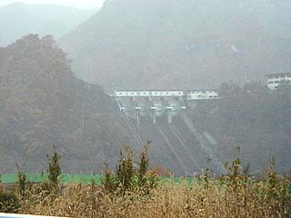
View of the levee from the downstream side of the right bank (zoom in on the flood discharge)
Well, it doesn't look clear at all.... I did some processing to make it look better.... Can someone tell me how to take beautiful pictures on a snowy day? I like snow, but I am not good at photographing on a snowy day....
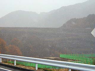
View of the embankment from the downstream side of the right bank (zoom in on the fill area)
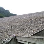
I have no idea what it is. It is a levee in case you are wondering. The riprap is also blurry.
View of the reduction work from the left bank
The levee was under construction at that time and dump trucks were coming and going several times. It was not off-limits, so we could cover the event, but it was a bit dangerous to try to go to the right bank, so we only covered the flood discharge area.
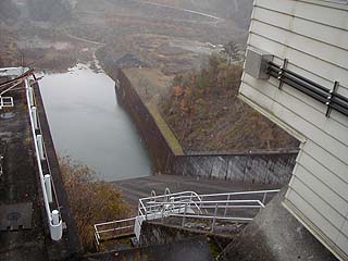
This construction work, whatever it is, seems to have been caused by a massive influx of earth and sand due to the 1984 earthquake in western Nagano Prefecture, which drastically increased the amount of sand deposited, and the Makio Dam is now undergoing redevelopment. However, it is unknown if this is the reason for the construction work at this time.
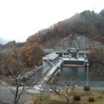
View of the radial gate from the left bank
There are four radial gates.
View of the dam lake from the left bank
dam characteristics
| Model | Center-core type rockfill dam |
| Objective | Irrigation water, water supply water, industrial water, power generation |
| Bank height | 104.5m |
| Bank length | 264m |
| Dam volume | 2,615,000m3 |
| Watershed Area | 304 km2 |
| Reservoir area | 247ha |
| Total storage capacity | 75,000,000m3 |
| Effective water storage capacity | 68,000,000m3 |
| Name of Dam Lake | lake (Ontake-ko) |
| Discharge Facilities | Howell Banger Valvephi1,800mm 1 gate |
| Maximum Residual Water Discharge | 3,200m3/sec |
| form (something takes) | Chute-type residual water discharge |
| gate | 4 tenter gates (10m x 10m) |
| River Name | Kiso River System Ohtaki River |
| Year of launch | 1957 |
| Year Completed | 1961 |
Other facilities/observations
I have my home slopes in this vicinity, so we may possibly meet during the snow season. Since I go there frequently, I have the impression that it is like a hometown in my heart. I just don't like National Highway 19, which I have to drive as fast as a highway.
| Parking lot | ○ |
| Toilet | ○ |
| Park | ○ |
| PR Exhibition Hall | × |
Comment
[...] 3321-Makio Dam The 2nd Meeting with Dam Lovers in Uren-Oshima Dam The 1st Meeting with Dam Lovers in Agigawa Dam " The 4th Meeting with Dam Lovers in Miyagawa Regulating Pond & Kasato Regulating Pond [...]
[...] 3321-Makio Dam "The 4th Gathering with Dam Lovers in Miyagawa Regulating Pond & Kasato Regulating Pond"! "The 4th Gathering with Dam Lovers in Miyagawa Regulating Pond & Kasato Regulating Pond"! [...].
[...] 3321-Makio Dam "The 4th Gathering with Dam Lovers in Miyagawa Regulating Pond & Kasato Regulating Pond"! Volume 2 of "Dam Manga" written by Yoshihisa Inoue was released today! "The 4th Gathering with Dam Lovers in [...]"!
[...] 3321-Makio Dam "The 4th Gathering with Dam Lovers in Miyagawa Regulating Pond & Kasato Regulating Pond"! Volume 2 of "Dam Manga" written by Yoshihisa Inoue was released today! Documentary video screening at the Tokyo Metropolitan Museum of Waterworks History [...].