

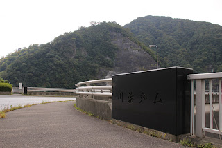
Location: Kawaji Onsen Kawaji, Nikko-shi, Tochigi
Date of interview: 2010/10/03 (Sun.)
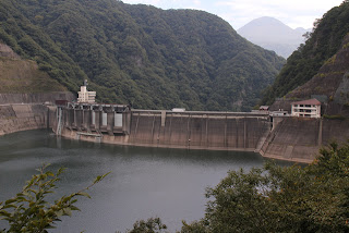
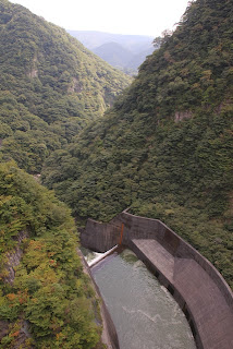
[Night view] View of the levee downstream from the right bank
![[Night view] View of the levee downstream from the right bank](https://dampedia.com/dam/wp-content/uploads/2022/10/image.jpeg)
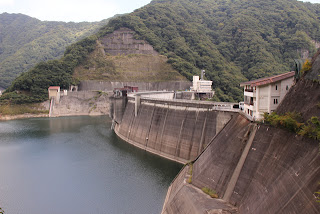
I visited Tochigi Prefecture to participate in the "Yunishigawa Dam Construction Site Tour (2010/10/02)," and finally reached the end of my tour of Kinugawa dams, which included the Imaichi Dam, Nakaiwa Dam, Koami Dam, Gojuri Dam, Mikawazawa Dam, Torobe Dam, Kurobe Dam (Tochigi), Kuriyama Dam, and Kawamata Dam. In fact, we wanted to visit other dams, but we were scheduled to leave Tochigi at noon that day, so Kawaji Dam was the last dam we would visit.
This photo is the result of my attempt to practice photographing the night view at Kawaji Dam before camping at Kuriyama Dam.... I still need more practice.
View of the embankment on the lake side from the right bank road
The next day, we came from Kawamata Dam to Kawaji Dam.
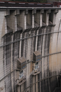
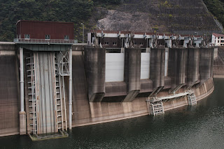
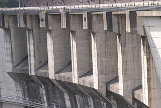
View of the flood discharge from the right bank road
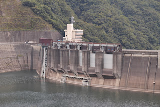
There are six emergency flood discharges at the crest, two conduit gates below, and a selective intake facility at the rear.
View of driftwood stoppage and other structures from the right bank road
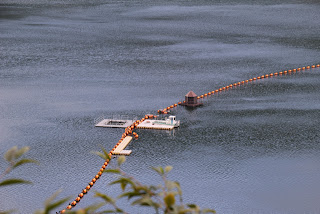
A driftwood stopper floating on a dam lake. Is that brown thing over there an aeration system?
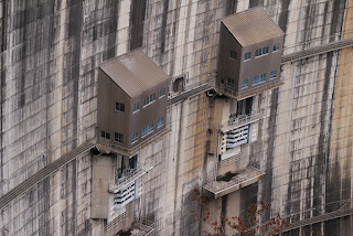
View of the "return pump" (presumably) that sends water back to the Gojuri Dam from the right bank road.
It is thought to be a "return pump" that sends water back to the Gojuri Dam from the Kawaji Dam, one of the "Kinugawa River Upper Stream Dam Group Linkage Facilities.
View of the embankment on the lake side of the dam from before the tunnel on the right bank
It is nice to see it from different angles.
Incidentally, the building in the foreground is the Kawaji Dam Museum and the building in the back is the Kawaji Dam Management Office.
View of the conduit gate from the right bank
The two gatesconduit gateI am not sure what to do about it. Still, I am concerned about the black spots on the wall surface.
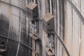
Amphibious bus visitors
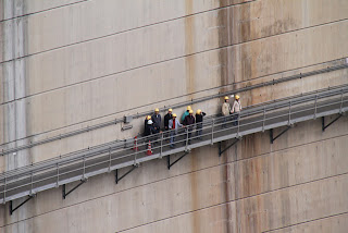
If you take an amphibious bus at Yunishigawa Roadside Station, you can visit the inside of the embankment & catwalk of Kawaji Dam. As I did not participate in this tour of the dam, I view it with envy from the dam site.
Incidentally, amphibious bus rides cost 3,000 yen for adults and can be reserved online. For details, see "Yunishikawa Duck Tour official websitePlease refer to the "See
View of the crest gate and conduit gate from the downstream side of the right bank
The thought of releasing them through the crest gate is a little scary, but I would love to see them live.
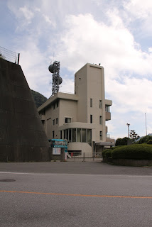
View of the management office from the right bank
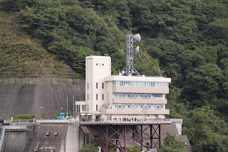
The Kawaji Dam control station is located at the left bank dam site. The blue object to the left of the administration office is an amphibious bus. You can see a small crowd of people on the scaffold (parking lot), but they are visitors who were on the bus.
View of the irrigation discharge from the right bank
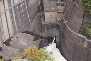
Looking directly down.
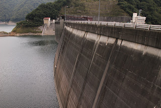
Looking downstream from the right bank
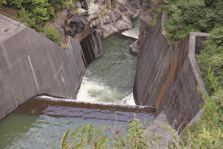
Further downstream.
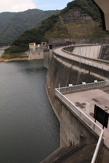
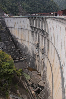
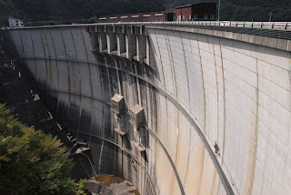
View of the embankment from the right bank
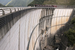
I think it was worth it for me to have a new digital camera with SLR for this day, but unfortunately, it did not lead to any good results.
But still, it is a nice arch. I can't stand it anymore.
At 140 m, the Kawaji Dam is the fourth tallest arch dam in Japan.
View of the top edge from the right bank
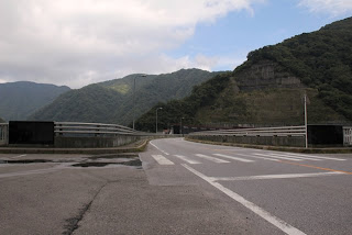
The top end is a prefectural road and is open to automobile traffic. It is one lane on each side, but feels wide.
View of the embankment on the lake side from the right bank dam site
The dam lake side also has a shape that is recognizable as an arch, but it looks very bulky.
View of the dam lake from the right bank dam site
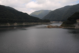
The dam lake is named "Yashio Lake. Yashio Dam (0582-Yashio Dam/Yashiodam) is located in the same Tochigi Prefecture, but there is absolutely no connection between the two.
View of the incline from the right bank dam site
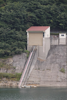
It seems a bit small compared to the scale. I'm sure there are others hidden away...(secret base?).
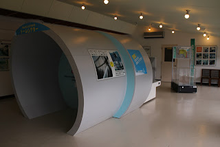
Kawaji Dam Museum
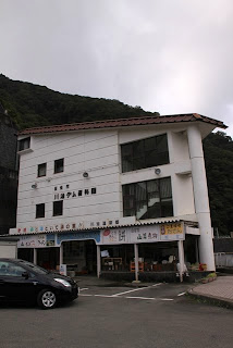
This is the Kawaji Dam Museum operated by Nikko City. The first floor of the museum is a restaurant where visitors can have a meal.
The next page reports on the inside of the museum.
Inside the Kawaji Dam Museum (2F)
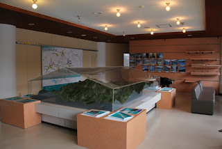
The store on the 1st floor is a no-brainer. Sorry.
There was no one in the archives.
When you go up to the second floor, a huge diorama sits on the floor.
Incidentally, you cannot get a Kawaji Dam card here, so you must go to the management office on the left bank.
*They can also get it at the museum.
Diorama of Kawaji Dam and Gojuri Dam
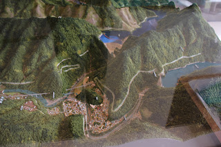
I did not yet have a PL filter at this time, so I apologize for the harsh reflections of the acrylic case covering the model. The Kawaji Dam is on the top in the middle, and the Gojuri Dam is on the left.
Aerial view of Kawaji Dam
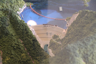
Aerial view of Kawaji Dam, WW
Sorry it's not real.
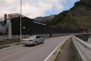
Inside the Kawaji Dam Museum (3F)
Next, go up to the 3rd floor.
The large dome-like structure is a replica of the conduit tunnel used in the "Kinugawa Upper Kinugawa River Dam Group Linkage Project" that connected the Kawaji Dam and the Gojuri Dam.
View of the embankment from Kawaji Dam Museum
Looking out the window, one can see the Kawaji Dam.
I was thinking here that if the museum were on the first or second floor and the eating and drinking on the third floor, we could have a meal while overlooking the dam. This is just my personal opinion. In addition, you have to pass through the museum to get to the eating and drinking area, so you can learn about nature and the dam.
If the museum itself is ever renovated, it would be better to move it to the downstream side of the dam site and make it a 3F building as well, with an observation deck.
Aerial view of Kawaji Dam
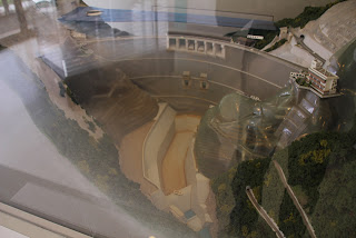
Putting such fantasies aside, there is a model on this floor as well. It is a model of Kawaji Dam. The Kawaji Dam cannot be seen from the downstream side, but in the photo, there seems to be a road for management at the lower right. It seems that the public is not allowed to enter...
View of the top edge and gate operation room
After a quick tour of the museum, we came to the top edge.
It is a large gate operation room.
View downstream from the top
After all, I can't find any place where I can see the levee from the downstream side....
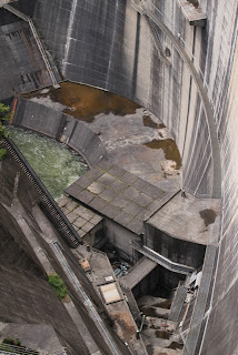
View of the selective intake system from the top

This is a selective intake low water discharge facility. It appears to consist of several gates.
Low water discharge facility specifications
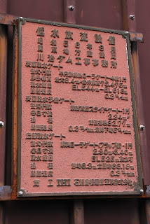
This is its spec table.
From the left bank dam site
We finally reached the left bank.
View of the gates from the left bank dam site
You can see the gate group in more detail from here.
View of the administration office
This is the administration office of Kawaji Dam.
It seems that the tour on the catwalk is not yet finished, and an amphibious bus is waiting by the administration office.
I wanted to get a dam card, but I was worried that I might be mistaken for a tour group, and while I was wondering what to do, an amphibious bus was leaving to return to the roadside station.
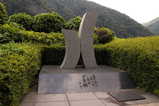
Stone monument by the gate of the administration office
Finally, now I can get my dam card! I think, and press the intercom.
Yes, yes, just a minute!"
We will hang around until the person at the management office brings us our dam cards.
I took a quick shot of a stone monument that I don't know what it says.
Gotta love the parking lot by the control center and the levee from where you can see it on the lower right!
I might be able to see the levee from the parking lot by the control center and (in this picture) from the lower right corner! I decided to negotiate with the management office in the hope that I would be able to see the dike....
Off-limits!
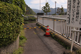
Oh, that!
Is it off-limits? I thought.
Look, we don't want to get mixed up with the amphibious bus tours, so here's what we're doing for now."
In other words, if visitors from the general public and those on amphibious buses were to mix, it would cause various problems, so a visible barrier was purposely put up.
'It doesn't mean you can't go in, but it doesn't mean you can't go in on your own.'
And it seems a bit choppy. But it seems to be gray on a dare.
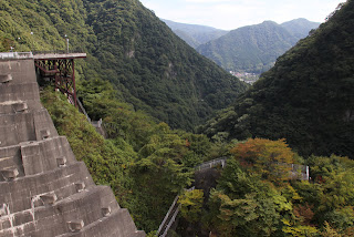
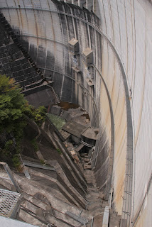
View of the downstream embankment from the left bank dam site
We managed to get permission to go to the side of the parking lot and to the point where we could worship from the downstream side.
If it were a local dam, I would have given up, but since it's a place I can't come to that often, I won't back down so easily from WW.
I heard that it is not 100% off-limits, but it would be better to ask for permission. It would be a good idea to negotiate with them while you are getting your dam card.
Still, it is a pretty good viewpoint.
View of the conduit gate from the left bank
The conduit gate is seen from the left bank, although it was also seen on the right bank.
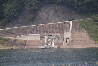
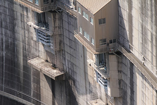
View of the flow-reducing structures and water discharge facilities from the left bank
It is a surprisingly complex mix of stairs and catwalks.
View from the left bank directly below the embankment
Hiyoe~...
It is so high that it seems to suck you in.
[Panel]The Nikko Earthquake and Gojuryosui
![[Panel]The Nikko Earthquake and Gojuryosui](https://dampedia.com/dam/wp-content/uploads/2022/10/image-38.jpeg)
A number of panels were posted in the parking lot by the administration office in front of the point where it could be worshipped from the downstream side.
You can also learn about history here.
During the Edo period (1603-1867), the Great Nikko Earthquake occurred, causing the mountains to collapse and damming up the Oga River, which in turn created Lake Gojuri. Lake Gojyuri is larger than Lake Gojyuri is today, and is a natural dam.
Forty years after the great earthquake, Lake Gojuri collapsed due to heavy rains, causing extensive damage downstream.
[Panel]The raging river "Kinugawa" flows like an angry demon.
![[Panel]The raging river "Kinugawa" flows like an angry demon.](https://dampedia.com/dam/wp-content/uploads/2022/10/image-39.jpeg)
The Kinugawa River has a history of flooding. That is why there are so many large dams.
Nishikawa area where [panel]Ninomiya Sontoku unpacked his boxes.
![Nishikawa area where [panel]Ninomiya Sontoku unpacked his boxes.](https://dampedia.com/dam/wp-content/uploads/2022/10/image-40.jpeg)
This neighborhood is said to be the land that Sontoku Ninomiya (Kinjiro Ninomiya) unpacked, and his ideas and accomplishments were summarized in a panel.
[Panel]Visitors to the West Aizu Highway
![[Panel]Visitors to the West Aizu Highway](https://dampedia.com/dam/wp-content/uploads/2022/10/image-41.jpeg)
The panel says that historical figures have also visited the area.
[Panel]Dam construction sites, then and now
![[Panel]Dam construction sites, then and now](https://dampedia.com/dam/wp-content/uploads/2022/10/image-42.jpeg)
The development of dams was active in this area, and with the exception of power generation-only and small-scale dams, the dams were built in the following order: 0559-Ikari Dam, 0563-Kawamata Dam, and 0571-Kawaji Dam.
[Panel]The Kinugawa River and the History of Hydroelectric Power Generation
![[Panel]The Kinugawa River and the History of Hydroelectric Power Generation](https://dampedia.com/dam/wp-content/uploads/2022/10/image-43.jpeg)
Of course, hydroelectric power generation is also thriving, and this panel explains that.
[Panel]Wish for the construction of the dam
![[Panel]Wish for the construction of the dam](https://dampedia.com/dam/wp-content/uploads/2022/10/image-44.jpeg)
This panel reminds us of the hardships faced during the construction of the Gojuri Dam.
[Panel]Yunishigawa Dam supports life and industry in the Tokyo metropolitan area.
![[Panel]Yunishigawa Dam supports life and industry in the Tokyo metropolitan area.](https://dampedia.com/dam/wp-content/uploads/2022/10/image-45.jpeg)
The panel then explains how the new Yunishigawa Dam joins the group and enriches our lives through water utilization.
[Panel]Yunishigawa Dam protects the lives and property of Tone River basin residents
![[Panel]Yunishigawa Dam protects the lives and property of Tone River basin residents](https://dampedia.com/dam/wp-content/uploads/2022/10/image-46.jpeg)
The panel also showed that the Yunishigawa Dam will also provide flood control benefits.
That's right. The Kinugawa River, a large river, joins the even larger Tone River downstream.
Protecting the Kinugawa River means protecting the urban areas downstream.
We must not forget that.
View of the levee downstream from the left bank
With these thoughts in mind, we continue to take more photographs.
It was just beginning to cloud over, but the sun peeked through the clouds and shone brightly on the embankment.
View of the conduit gate from the left bank
Protecting the downstreamordinary flood dischargeThe following is a list of the most common problems with the
It is, as it were, a warrior's rest now.
View of the crest gate from the left bank
andemergency flood dischargeThe following is a list of the most common problems with the
The water spewed out from here is a sign that it is protecting the downstream.
The blackening of the embankment, which had been bothering me since the beginning of the interview, may be the pride and order of such Kawaji Dam.
...And unfortunately, the time has come. I had a lot of experiences on the dam tour upstream of the Kinugawa River, and I would definitely like to revisit the tour again.
[aside].
It is a point that seems to be visible from the downstream side, but I actually went there but could not see the bank at all because it was overgrown with grass and trees......orz
dam characteristics
| River Name | Tone River System Kinugawa River |
| Objective | Flood control, agricultural disaster prevention, unspecified water, river maintenance water, irrigation water, water supply water, industrial water |
| Model | arch dam |
| Bank height | 140m |
| Bank length | 320m |
| Dam volume | 700,000m3 |
| Watershed Area | 323.2 km2 |
| Reservoir area | 220ha |
| Total storage capacity | 83,000,000m3 |
| Effective water storage capacity | 76,000,000m3 |
| Dam operator | Kanto Regional Construction Bureau |
| Main body constructor | Kajima Construction |
| Year of launch | 1968. |
| Year Completed | 1983 |
| Name of Dam Lake | Yashio Lake |
Other facilities/observations
Anyway, there are many sights to see. After all, there is the arch dam. I definitely recommend it. I also highly recommend the catwalk experience (which I have not experienced at this point).
| Parking lot | ○ |
| Toilet | ○ |
| Park | × |
| PR Exhibition Hall | ○ |
| Fishing | ○ |

Comment