
Location: Makino, Fujino-cho, Tsukui-gun, Kanagawa Prefecture
Official Web site:.Water Utilization Division, Water Utilization and Electricity Department, Kanagawa Prefectural Enterprise Bureau
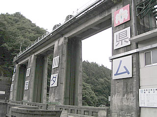
View of the embankment from the left bank
The dam is located on the border between Kanagawa and Yamanashi prefectures, and is easily found because a prefectural road runs along the top edge.
It features three roller gates, and although it is small, the design of the parapet tells of the good old days.

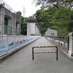
Downstream view of the levee from the left bank
The moss stuck to the embankment also adds a nice flavor.
The name "Doshi" is "Doshi" for "aspiring to be". It is a really good-sounding name. I tried to look up the origin of the name on the Internet, but I could not find it after all.

However, if it is permissible to add an afterthought to the origin of the name, it should be "Mizu no Michi wo Shisu" (aspiring for the path of water), since Yokohama City and Doshi Village have maintained a friendly relationship since Yokohama City started taking water from the Doshi River in 1897.
The water of the Doshi River is sometimes (sometimes?) shipped on foreign routes and transported overseas. It is said that the water of the Doshi River was highly praised by sailors for "not spoiling even if it crossed the equator.
View of the gate from the top
A gate full of bird flu. Even here, we are affected by bird damage (laughs).

View of the dam lake from the top
It looks like a good spot for fishing, but it is not known if fishing is possible or not. However, there is no such thing as a road or riverbank along the dam lake, so fishing may not be possible.

View downstream from the top
0.3m3Discharging water for river maintenance at /s.

View of the outlet from the top
There was a little bit of water coming out of the gate, perhaps leaking from the gate. Well, this is also water for river maintenance... (lie)

View of the embankment from the right bank
We came from Sagami Lake, but the distance is reasonable, so it was quiet as if the hustle and bustle at Sagami Lake was a lie.

dam characteristics
| Model | gravity-fed concrete dam |
| Objective | Irrigation/water supply/power generation |
| Bank height | 32.8m |
| Bank length | 74m |
| Dam volume | 23,500m3 |
| Watershed Area | 225.5 km2 |
| Reservoir area | 14 ha |
| Total storage capacity | 1,525,000m3 |
| Effective water storage capacity | 616,000m3 |
| River Name | Sagami River System Doshi River |
| Year of launch | 1953. |
| Year Completed | 1955 |
| Access to D@M | Get off at Sagami Lake IC of Chuo Expressway turning right at a traffic light Go west for a while and turn left at the intersection with Prefectural Road 76. The rest of the way south, you will reach the dike. |
Other facilities/observations
Although the dam itself has no ancillary facilities, if you drive National Route 413 in the direction of Doshi Village, you will see theHot water of red camelliaThere is a day spa that can also accommodate overnight stays called It is also a good place to recover from the fatigue of your trip.
| Parking lot | × |
| Toilet | × |
| Park | × |
| PR Exhibition Hall | × |
Accommodations that may be close to Doshi Dam
Comment