
Location: 1 Shiroyama, Shiroyama-cho, Tsukui-gun, Kanagawa Prefecture
Official Web site:.Water Utilization Bureau, Kanagawa Prefectural Enterprise Agency
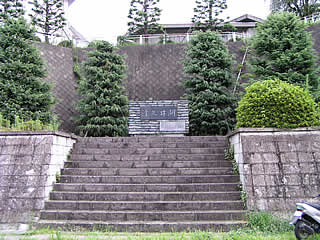
Stone monument placed on the right bank (written as Lake Tsukui)
")
Because Shiroyama Dam is close to central Tokyo and to Sagami Lake, which most leisure-seekers in the Kanto region have visited, the surrounding roads are very busy with cars on their way to the dam. In addition, National Route 413 runs along the top of the dam, which may be the only national road in Japan with such a heavy traffic volume.
However, everyone is indifferent to the levee itself, just passing through.... The Tenbata National Highway is nothing more than a bridge to the general public....
Still, the fact that there are family restaurants, convenience stores, and apartment complexes near the dam is as expected of a dam in the Kanto region. I am sure there are some in the Chubu region as well, but it is hard to find a dam that is so crowded with people and has everything in its vicinity.
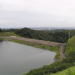
View of the embankment (lake side) from the right bank
 from the right bank")
The cars are hidden by the parapet, but it was near evening at that time, so there were very many cars heading toward the city center. The water in the dam lake was a match brown color, and it was dirty or emitted an unpleasant stench. I felt that this was indeed an urban dam.
View of the water intake and dam lake from the right bank

Hmmm...and it still stinks...
Garbage disposal facility?

Perhaps this is a machine that disposes of trash from the dam lake.
View of the top edge from the left bank

There is a viewing platform on the downstream side of the left bank, but we had to cross this pedestrian crossing and decided against going up due to heavy traffic and time constraints. We wanted to look downstream from the top, but gave up in despair.
dam characteristics
| da mu | Model | gravity-fed concrete dam |
|---|---|---|
| Objective | Flood control, agricultural disaster prevention/. Water for waterworks / Industrial water / Power generation | |
| Bank height | 75m | |
| Bank length | 260m | |
| Dam volume | 362,000m3 | |
| savings water (esp. cool, fresh water, e.g. drinking water) pond | Watershed Area | 1222.1 km2 |
| Reservoir area | 247ha | |
| Total storage capacity | 62,300,000m3 | |
| Effective water storage capacity | 54,700,000m3 | |
| Name of Dam Lake | Lake Tsukui | |
| River Name | Sagami River System Sagami River | |
| Year of launch | 1960. | |
| Year Completed | 1964 | |
| Access to D@M | Get off at Sagami Lake IC (or Sagami Lake East Exit) on Chuo Expressway Take Route 20 toward Hachioji (Sagamiko East Exit toward Yamanashi) At the T intersection with Route 412, turn right onto Route 412 (from Sagami Lake East Exit, turn left) Sagami Dam can be seen on the left on the way. The rest of the way, just keep going on the national highway toward Sagamihara City. On the way, at the intersection in front of Tsukui High School, the road turns into Route 413, so go straight. The rest is just down the road. | |
Other facilities/observations
| Parking lot | ○ | My goodness, I just realized while I was working on this page. Discovered that there is a PR exhibition hall called "Lake Tsukui Memorial Hall!" The restrooms and parking lot are also surprisingly well-equipped considering the use of the facilities there. The Lake Tsukui Memorial Hall was built by the prefecture one year after the dam was constructed. It was organized by submerged people who advocated against the dam construction at the time. It seems that the "Kanagawa Prefecture Lake Tsukui Association" is in charge of the management of the pavilion. |
|---|---|---|
| Toilet | ○ | |
| Park | ○ | |
| PR Exhibition Hall | ○ |

Comment